
Fai una donazione
Preparati per la tua prossima avventura:
In qualità di associato Amazon, questo sito riceve una commissione sugli acquisti idonei senza alcun costo aggiuntivo per te.
Mappa topografica Megisti
Clicca sulla mappa per visualizzare l'altitudine.
Fai una donazione
Preparati per la tua prossima avventura:
In qualità di associato Amazon, questo sito riceve una commissione sugli acquisti idonei senza alcun costo aggiuntivo per te.
Megisti
West of the town, beyond the summit of the island known as Vigla (270 m), stands Palaiokastro (old castle), the island's ancient acropolis. This fortified elevation has classical origins (see below, history section): its plan is rectangular and measures 60 by 80 metres (200 ft × 260 ft). In its interior stand an ancient tower, built with square limestone blocks, and large water cisterns. Carved on the base of the castle there is also a Doric inscription, dating back to the 4th or 3rd centuries BC, with references to Megiste (the ancient name of Kastellorizo) and its dependence on Rhodes. On the east side there are remnants of a gateway, or propylaea.
Fai una donazione
Preparati per la tua prossima avventura:
In qualità di associato Amazon, questo sito riceve una commissione sugli acquisti idonei senza alcun costo aggiuntivo per te.
A proposito di questa mappa
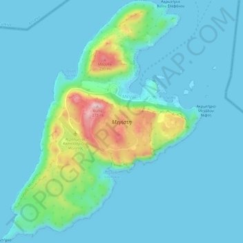
Nome: Mappa topografica Megisti, altitudine, rilievo.
Altitudine media: 40 m
Altitudine minima: 0 m
Altitudine massima: 265 m
Fai una donazione
Preparati per la tua prossima avventura:
In qualità di associato Amazon, questo sito riceve una commissione sugli acquisti idonei senza alcun costo aggiuntivo per te.