
Fai una donazione
Preparati per la tua prossima avventura:
In qualità di associato Amazon, questo sito riceve una commissione sugli acquisti idonei senza alcun costo aggiuntivo per te.
Mappa topografica Fleetwith Pike
Clicca sulla mappa per visualizzare l'altitudine.
Fai una donazione
Preparati per la tua prossima avventura:
In qualità di associato Amazon, questo sito riceve una commissione sugli acquisti idonei senza alcun costo aggiuntivo per te.
Fleetwith Pike
The fell itself is often climbed in conjunction with other neighbouring fells such as Haystacks and Grey Knotts; strong walkers may also take in the peaks of Great Gable and Green Gable. There are two possible starting points for the ascent of Fleetwith Pike: these are Gatesgarth in the Buttermere valley and the top of the Honister pass. Both places have car parks. The start from Honister Hause has the advantage of starting from a height of 356 metres (1,168 feet) and takes the walker through the quarry workings of the Honister Slate Mine and over Black Star, the highest point of Honister Crag at 630 metres (2,070 feet). Honister Crag was upgraded to become a Nuttall fell in November 2004, the first addition to the list since they were first published in 1990, it has 20 metres (66 feet) of topographical prominence from Fleetwith Pike. After crossing Honister Crag it is a simple walk to attain the top of Fleetwith Pike. The ascent from Gatesgarth goes up the intimidating-looking Fleetwith Edge; however, all the crags can be by-passed without too much difficulty. This route goes past a white cross which is clearly visible from the valley and bears the inscription "Erected by Friends of Fanny Mercer, accidentally killed 1887".
Fai una donazione
Preparati per la tua prossima avventura:
In qualità di associato Amazon, questo sito riceve una commissione sugli acquisti idonei senza alcun costo aggiuntivo per te.
A proposito di questa mappa
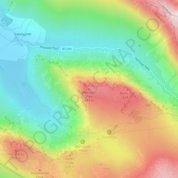
Nome: Mappa topografica Fleetwith Pike, altitudine, rilievo.
Altitudine media: 360 m
Altitudine minima: 102 m
Altitudine massima: 731 m
Fai una donazione
Preparati per la tua prossima avventura:
In qualità di associato Amazon, questo sito riceve una commissione sugli acquisti idonei senza alcun costo aggiuntivo per te.