
Fai una donazione
Preparati per la tua prossima avventura:
In qualità di associato Amazon, questo sito riceve una commissione sugli acquisti idonei senza alcun costo aggiuntivo per te.
Mappa topografica Neyyatinkara
Clicca sulla mappa per visualizzare l'altitudine.
Fai una donazione
Preparati per la tua prossima avventura:
In qualità di associato Amazon, questo sito riceve una commissione sugli acquisti idonei senza alcun costo aggiuntivo per te.
Neyyatinkara
Neyyattinkara is located at 8°24′N 77°05′E / 8.4°N 77.08°E / 8.4; 77.08. It has an average elevation of 26 metres (85 feet). The town is situated on the Neyyar River side, one of the principal rivers in Thiruvananthapuram district. The river flows to the south part of the town. Water Supply for the town and the adjacent places is obtained from this river. Topography of the town is rather uneven, with higher areas in the downtown. Nearby the town is the hillock Aruvippuram. The Western Ghats form a scenic backdrop to the town. The town is sandwiched between the Western Ghats and the Arabian Sea. The nearby sea shore is just 10 km. away in west, and seven kilometres to the east can take you to the mammoth hillocks of Western ghats. The geology is said to be typical of the Kerala soil - the Laterite and red soil. The town can still boast of a good green cover in residential and non-residential areas.
Fai una donazione
Preparati per la tua prossima avventura:
In qualità di associato Amazon, questo sito riceve una commissione sugli acquisti idonei senza alcun costo aggiuntivo per te.
A proposito di questa mappa
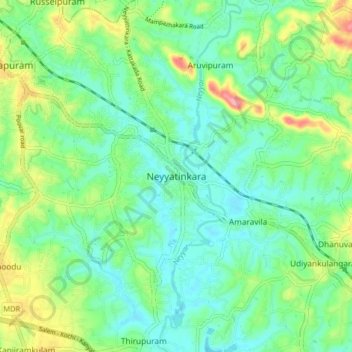
Nome: Mappa topografica Neyyatinkara, altitudine, rilievo.
Altitudine media: 38 m
Altitudine minima: 5 m
Altitudine massima: 118 m
Fai una donazione
Preparati per la tua prossima avventura:
In qualità di associato Amazon, questo sito riceve una commissione sugli acquisti idonei senza alcun costo aggiuntivo per te.
Altre mappe topografiche
Clicca su una mappa per visualizzarne la topografia, l'altitudine e il rilievo.