
Fai una donazione
Preparati per la tua prossima avventura:
In qualità di associato Amazon, questo sito riceve una commissione sugli acquisti idonei senza alcun costo aggiuntivo per te.
Mappa topografica Bayang
Clicca sulla mappa per visualizzare l'altitudine.
Fai una donazione
Preparati per la tua prossima avventura:
In qualità di associato Amazon, questo sito riceve una commissione sugli acquisti idonei senza alcun costo aggiuntivo per te.
Bayang
The topography of the municipality is generally characterized by moderately sloping lands. Approximately 2,606 hectares (63.45%) have moderate slopes of 8 – 15%. Steep lands with a slope 40 – 60% comprise 20.14% (827) ha. About 674 (16.41) have nearly level terrain.
Fai una donazione
Preparati per la tua prossima avventura:
In qualità di associato Amazon, questo sito riceve una commissione sugli acquisti idonei senza alcun costo aggiuntivo per te.
A proposito di questa mappa
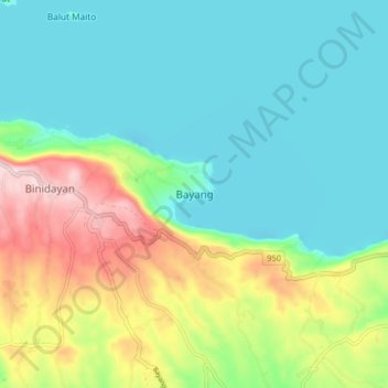
Nome: Mappa topografica Bayang, altitudine, rilievo.
Luogo: Bayang, Lanao del Sur, Bangsamoro, Philippines (7.75373 124.15720 7.83373 124.23720)
Altitudine media: 782 m
Altitudine minima: 688 m
Altitudine massima: 1.013 m
Fai una donazione
Preparati per la tua prossima avventura:
In qualità di associato Amazon, questo sito riceve una commissione sugli acquisti idonei senza alcun costo aggiuntivo per te.
Altre mappe topografiche
Clicca su una mappa per visualizzarne la topografia, l'altitudine e il rilievo.
Lake Lanao
The lake has great hydroelectric potential due to its 700 meter elevation, and as such, in 1950, the Philippines National Power Corporation (NAPOCOR) began the construction of a series of hydroelectric plants titled Agus I – Agus VII along the Agus River system, which generates 70% of the electricity used by…
Altitudine media: 787 m
Marawi City
Marawi is located upon the shores of Lake Lanao. It is primarily inhabited by the Maranao people. The city is also called the "Summer Capital of the South" due to its higher elevation and cooler climate, a nickname it shares with Malaybalay.
Altitudine media: 707 m
Fai una donazione
Preparati per la tua prossima avventura:
In qualità di associato Amazon, questo sito riceve una commissione sugli acquisti idonei senza alcun costo aggiuntivo per te.
Marawi
Marawi is located upon the shores of Lake Lanao. It is primarily inhabited by the Maranao people. The city is also called the "Summer Capital of the South" due to its higher elevation and cooler climate, a nickname it shares with Malaybalay.
Altitudine media: 708 m
Marawi
Marawi is located upon the shores of Lake Lanao. It is primarily inhabited by the Maranao people. The city is also called the "Summer Capital of the South" due to its higher elevation and cooler climate, a nickname it shares with Malaybalay.
Altitudine media: 708 m
Marawi City
Marawi is located upon the shores of Lake Lanao. It is primarily inhabited by the Maranao people. The city is also called the "Summer Capital of the South" due to its higher elevation and cooler climate, a nickname it shares with Malaybalay.
Altitudine media: 707 m
Fai una donazione
Preparati per la tua prossima avventura:
In qualità di associato Amazon, questo sito riceve una commissione sugli acquisti idonei senza alcun costo aggiuntivo per te.