
Mappa topografica City of London
Mappa interattiva
Clicca sulla mappa per visualizzare l'altitudine.
A proposito di questa mappa
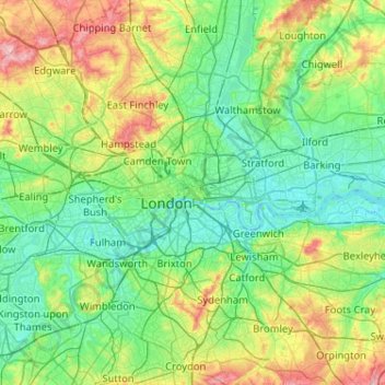
Nome: Mappa topografica City of London, altitudine, rilievo.
Luogo: City of London, England, EC2V 5AE, United Kingdom (51.35562 -0.25200 51.67562 0.06800)
Altitudine media: 42 m
Altitudine minima: -3 m
Altitudine massima: 166 m
The elevation of the City ranges from sea level at the Thames to 21.6 metres (71 ft) at the junction of High Holborn and Chancery Lane. Two small but notable hills are within the historic core, Ludgate Hill to the west and Cornhill to the east. Between them ran the Walbrook, one of the many "lost" rivers or streams of London (another is the Fleet).
Altre mappe topografiche
Clicca su una mappa per visualizzarne la topografia, l'altitudine e il rilievo.
The Fleet
United Kingdom > England > City of London > City of London
The Fleet, London Borough of Camden, City of London, Greater London, England, NW1 8NZ, United Kingdom
Altitudine media: 41 m