
Fai una donazione
Preparati per la tua prossima avventura:
In qualità di associato Amazon, questo sito riceve una commissione sugli acquisti idonei senza alcun costo aggiuntivo per te.
Mappa topografica O'Neal Island
Clicca sulla mappa per visualizzare l'altitudine.
Fai una donazione
Preparati per la tua prossima avventura:
In qualità di associato Amazon, questo sito riceve una commissione sugli acquisti idonei senza alcun costo aggiuntivo per te.
A proposito di questa mappa
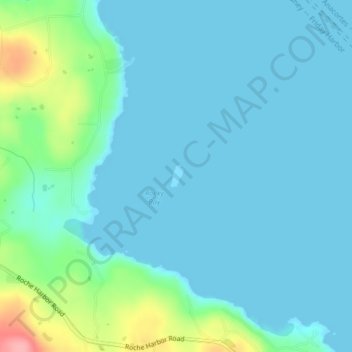
Nome: Mappa topografica O'Neal Island, altitudine, rilievo.
Luogo: O'Neal Island, San Juan County, Washington, United States (48.60294 -123.09339 48.60468 -123.09181)
Altitudine media: 18 m
Altitudine minima: 0 m
Altitudine massima: 108 m
Fai una donazione
Preparati per la tua prossima avventura:
In qualità di associato Amazon, questo sito riceve una commissione sugli acquisti idonei senza alcun costo aggiuntivo per te.
Altre mappe topografiche
Clicca su una mappa per visualizzarne la topografia, l'altitudine e il rilievo.
Orcas Island
United States > Washington > San Juan County > Eastsound
Orcas Island presents one of the most dramatic relief profiles in Washington’s San Juan Islands, rising abruptly from the sheltered waters of the Salish Sea to the summit of Mount Constitution, the archipelago’s highest point at about 2,409 feet (734 m). Its topography is strongly organized around steep,…
Altitudine media: 59 m
Fai una donazione
Preparati per la tua prossima avventura:
In qualità di associato Amazon, questo sito riceve una commissione sugli acquisti idonei senza alcun costo aggiuntivo per te.
Fai una donazione
Preparati per la tua prossima avventura:
In qualità di associato Amazon, questo sito riceve una commissione sugli acquisti idonei senza alcun costo aggiuntivo per te.
Orcas Island
United States > Washington > San Juan County > Eastsound
Orcas Island presents one of the most dramatic relief profiles in Washington’s San Juan Islands, rising abruptly from the sheltered waters of the Salish Sea to the summit of Mount Constitution, the archipelago’s highest point at about 2,409 feet (734 m). Its topography is strongly organized around steep,…
Altitudine media: 59 m
Fai una donazione
Preparati per la tua prossima avventura:
In qualità di associato Amazon, questo sito riceve una commissione sugli acquisti idonei senza alcun costo aggiuntivo per te.
San Juan Islands National Wildlife Refuge
United States > Washington > San Juan County
Altitudine media: 24 m
Fai una donazione
Preparati per la tua prossima avventura:
In qualità di associato Amazon, questo sito riceve una commissione sugli acquisti idonei senza alcun costo aggiuntivo per te.
Orcas Island
United States > Washington > San Juan County > Eastsound
Orcas Island presents one of the most dramatic relief profiles in Washington’s San Juan Islands, rising abruptly from the sheltered waters of the Salish Sea to the summit of Mount Constitution, the archipelago’s highest point at about 2,409 feet (734 m). Its topography is strongly organized around steep,…
Altitudine media: 59 m
Fai una donazione
Preparati per la tua prossima avventura:
In qualità di associato Amazon, questo sito riceve una commissione sugli acquisti idonei senza alcun costo aggiuntivo per te.