
Mappa topografica Ashby Woulds
Mappa interattiva
Clicca sulla mappa per visualizzare l'altitudine.
A proposito di questa mappa
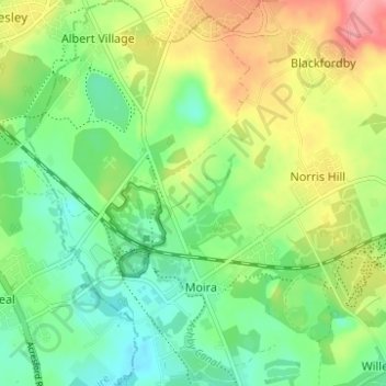
Nome: Mappa topografica Ashby Woulds, altitudine, rilievo.
Altitudine media: 111 m
Altitudine minima: 75 m
Altitudine massima: 169 m
Altre mappe topografiche
Clicca su una mappa per visualizzarne la topografia, l'altitudine e il rilievo.
Castle Donington
United Kingdom > England > North West Leicestershire > Castle Donington
Castle Donington, Leicestershire, East Midlands, England, DE74 2NS, United Kingdom
Altitudine media: 62 m
Ashby de la Zouch
United Kingdom > England > North West Leicestershire > Ashby de la Zouch
Ashby de la Zouch, Leicestershire, East Midlands, England, LE65 1AN, United Kingdom
Altitudine media: 128 m
Measham
United Kingdom > England > North West Leicestershire > Measham
Measham, North West Leicestershire, Leicestershire, East Midlands, England, DE12 7EB, United Kingdom
Altitudine media: 97 m
Normanton le Heath
United Kingdom > England > North West Leicestershire > Normanton le Heath
Normanton le Heath, North West Leicestershire, Leicestershire, East Midlands, England, LE67 2TB, United Kingdom
Altitudine media: 123 m
Oakthorpe
United Kingdom > England > North West Leicestershire > Oakthorpe
Oakthorpe, North West Leicestershire, Leicestershire, East Midlands, England, DE12 7RB, United Kingdom
Altitudine media: 94 m
Osgathorpe
United Kingdom > England > North West Leicestershire > Osgathorpe
Osgathorpe, North West Leicestershire, Leicestershire, East Midlands, England, LE12 9SZ, United Kingdom
Altitudine media: 97 m