
Mappa topografica Lansing
Mappa interattiva
Clicca sulla mappa per visualizzare l'altitudine.
A proposito di questa mappa
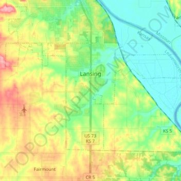
Nome: Mappa topografica Lansing, altitudine, rilievo.
Luogo: Lansing, Leavenworth County, Kansas, 66043, United States (39.20284 -94.96581 39.27422 -94.82651)
Altitudine media: 266 m
Altitudine minima: 225 m
Altitudine massima: 337 m
Altre mappe topografiche
Clicca su una mappa per visualizzarne la topografia, l'altitudine e il rilievo.
Maywood
United States > Kansas > Leavenworth County > Leavenworth
Maywood, Leavenworth, Leavenworth County, Kansas, 64092, United States
Altitudine media: 246 m
Fairmount
United States > Kansas > Leavenworth County
Fairmount, Leavenworth County, Kansas, United States
Altitudine media: 290 m
Leavenworth
United States > Kansas > Leavenworth County
Leavenworth, Leavenworth County, Kansas, United States
Altitudine media: 268 m
Linwood
United States > Kansas > Leavenworth County
Linwood, Leavenworth County, Kansas, United States
Altitudine media: 248 m
Hoge
United States > Kansas > Leavenworth County
Hoge, Leavenworth County, Kansas, United States
Altitudine media: 276 m
Basehor
United States > Kansas > Leavenworth County
Basehor, Leavenworth County, Kansas, 66007, United States
Altitudine media: 286 m
Fort Leavenworth
United States > Kansas > Leavenworth County > Leavenworth > Leavenworth
Fort Leavenworth, Leavenworth, Leavenworth County, Kansas, 66027, United States
Altitudine media: 252 m
Leavenworth
United States > Kansas > Leavenworth County > Leavenworth
Leavenworth, Leavenworth County, Kansas, 66048, United States
Altitudine media: 277 m