
Fai una donazione
Preparati per la tua prossima avventura:
In qualità di associato Amazon, questo sito riceve una commissione sugli acquisti idonei senza alcun costo aggiuntivo per te.
Mappa topografica Rabbit Ears Pass
Clicca sulla mappa per visualizzare l'altitudine.
Fai una donazione
Preparati per la tua prossima avventura:
In qualità di associato Amazon, questo sito riceve una commissione sugli acquisti idonei senza alcun costo aggiuntivo per te.
Rabbit Ears Pass
Although lower in elevation than many of the high mountain passes farther to the south in the Colorado Rockies, Rabbit Ears Pass often receives a great deal of snow in winter and is subject to regular short closures during heavy winter storms. The seasonal snowpack on this pass is a major source of water for residence in the nearby area. Rabbit Ears pass is a place for many different outdoor recreational activities. In the winter, it is a popular spot for back country snowboarding and skiing, cross-country skiing, and snowshoeing. There are boundaries set up to separate motorized use from foot traffic. These established boundaries decrease conflicts between users and seasonal closures related to snow depth and animal wintering ranges. Non-motorized recreation is permitted west of the pass and motorized recreation is permitted east of the pass. The boundary designating winter recreational usage on Rabbit Ears Pass provides an opportunity to study the influence of motorized recreation on the physical properties of the snowpack and animal use. The United States Department of Agriculture (USDA) Forest Service managing the Routt National Forest has not only implemented boundary regulations, but they have also put into effect regulatory practices designating the start of the snowmobile season when the unpacked snow depth equals or exceeds 30 cm (12 inches). There have been limited studies regarding the effectiveness of the current management plan with respect to an adequate snow depth that would minimize the potential impact motorized winter recreationalists have on this seasonal habitat.
Fai una donazione
Preparati per la tua prossima avventura:
In qualità di associato Amazon, questo sito riceve una commissione sugli acquisti idonei senza alcun costo aggiuntivo per te.
A proposito di questa mappa
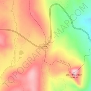
Nome: Mappa topografica Rabbit Ears Pass, altitudine, rilievo.
Luogo: Rabbit Ears Pass, Grand County, Colorado, United States (40.38402 -106.61190 40.38412 -106.61180)
Altitudine media: 2.852 m
Altitudine minima: 2.694 m
Altitudine massima: 2.962 m
Fai una donazione
Preparati per la tua prossima avventura:
In qualità di associato Amazon, questo sito riceve una commissione sugli acquisti idonei senza alcun costo aggiuntivo per te.
Altre mappe topografiche
Clicca su una mappa per visualizzarne la topografia, l'altitudine e il rilievo.
Fraser
United States > Colorado > Grand County
Fraser is located in southeastern Grand County at 39°56′39″N 105°48′48″W / 39.94417°N 105.81333°W / 39.94417; -105.81333 (39.944158, -105.813355), at an elevation of 8,574 feet (2,613 m) above sea level. It is bordered to the south by the town of Winter Park and to the north by…
Altitudine media: 2.696 m
Fai una donazione
Preparati per la tua prossima avventura:
In qualità di associato Amazon, questo sito riceve una commissione sugli acquisti idonei senza alcun costo aggiuntivo per te.
Hot Sulphur Springs
United States > Colorado > Grand County
Hot Sulphur Springs is a statutory town and the county seat of Grand County, Colorado, United States. The town is located near Byers Canyon between Granby and Kremmling, 95 miles (153 km) northwest of Denver and 30 miles (48 km) northwest of Winter Park. The town population was 687 at the 2020 census. Its…
Altitudine media: 2.446 m