
Fai una donazione
Preparati per la tua prossima avventura:
In qualità di associato Amazon, questo sito riceve una commissione sugli acquisti idonei senza alcun costo aggiuntivo per te.
Mappa topografica Ashhurst
Clicca sulla mappa per visualizzare l'altitudine.
Fai una donazione
Preparati per la tua prossima avventura:
In qualità di associato Amazon, questo sito riceve una commissione sugli acquisti idonei senza alcun costo aggiuntivo per te.
A proposito di questa mappa
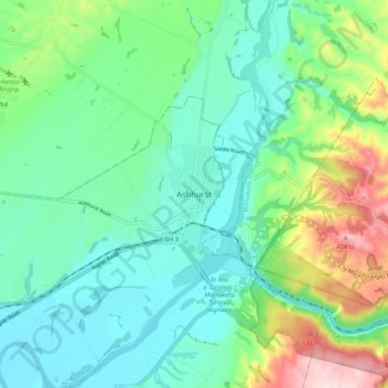
Nome: Mappa topografica Ashhurst, altitudine, rilievo.
Luogo: Ashhurst, Manawatū-Whanganui, 4810, New Zealand (-40.32933 175.71576 -40.24933 175.79576)
Altitudine media: 140 m
Altitudine minima: 38 m
Altitudine massima: 424 m
Fai una donazione
Preparati per la tua prossima avventura:
In qualità di associato Amazon, questo sito riceve una commissione sugli acquisti idonei senza alcun costo aggiuntivo per te.
Altre mappe topografiche
Clicca su una mappa per visualizzarne la topografia, l'altitudine e il rilievo.
Palmerston North City
New Zealand > Manawatu-Whanganui
Although the land Palmerston North is situated on is bounded by the lofty Ruahine and Tararua ranges in the east and south respectively, the city has a predominantly flat appearance. The occasional rise in elevation occurs further away from the river and is especially pronounced in the north and northeast, and…
Altitudine media: 133 m
Fai una donazione
Preparati per la tua prossima avventura:
In qualità di associato Amazon, questo sito riceve una commissione sugli acquisti idonei senza alcun costo aggiuntivo per te.
Manawatū River
New Zealand > Manawatu-Whanganui
At the time of human arrival, the Manawatū Plains were covered with forest. Towards the foothills and the Manawatū Gorge grew black beech, turning into tawa forest at lower altitudes. Along the plains and terraces the forest was mixed podocarp and tōtara, changing to mixed tawa, tītoki, and māhoe in the…
Altitudine media: 275 m
Fai una donazione
Preparati per la tua prossima avventura:
In qualità di associato Amazon, questo sito riceve una commissione sugli acquisti idonei senza alcun costo aggiuntivo per te.
Fai una donazione
Preparati per la tua prossima avventura:
In qualità di associato Amazon, questo sito riceve una commissione sugli acquisti idonei senza alcun costo aggiuntivo per te.
Mangawhero River
New Zealand > Manawatu-Whanganui
The source of the Mangawhero River is located on the slopes of Mt Ruapehu at elevation of approximately 1,800 m (5,900 ft). The river begins within the area of the Tūroa skifield and flows down the slopes of the mountain in a south west direction. The Ohakune Mountain Road, built during the 1950s and 60s,…
Altitudine media: 460 m
Fai una donazione
Preparati per la tua prossima avventura:
In qualità di associato Amazon, questo sito riceve una commissione sugli acquisti idonei senza alcun costo aggiuntivo per te.
Fai una donazione
Preparati per la tua prossima avventura:
In qualità di associato Amazon, questo sito riceve una commissione sugli acquisti idonei senza alcun costo aggiuntivo per te.
Ohakune
New Zealand > Manawatu-Whanganui > Ruapehu District
Ohakune is located in the Ruapehu District and the Manawatū-Whanganui region, to the immediate south-west of the slopes of the Mount Ruapehu stratovolcano. The associated Ohakune volcanic complex is just to the north of the town and the small maar lakes Rangatauanui and Rangatauaiti are to the south of the…
Altitudine media: 595 m
Waiouru
New Zealand > Manawatu-Whanganui > Ruapehu District
Waiouru's climate is mild, with very little temperature variation from month to month throughout the year, but because of its high altitude and close proximity to Mt Ruapehu it is still relatively cool compared to other North Island population centres, and can get quite cold at anytime of the year when the…
Altitudine media: 814 m
Fai una donazione
Preparati per la tua prossima avventura:
In qualità di associato Amazon, questo sito riceve una commissione sugli acquisti idonei senza alcun costo aggiuntivo per te.
Fai una donazione
Preparati per la tua prossima avventura:
In qualità di associato Amazon, questo sito riceve una commissione sugli acquisti idonei senza alcun costo aggiuntivo per te.
Lake Wiritoa
New Zealand > Manawatu-Whanganui > Whanganui District > Whanganui > Pauri Village
Altitudine media: 50 m
Fai una donazione
Preparati per la tua prossima avventura:
In qualità di associato Amazon, questo sito riceve una commissione sugli acquisti idonei senza alcun costo aggiuntivo per te.
Lake Pauri
New Zealand > Manawatu-Whanganui > Whanganui District > Whanganui > Pauri Village
Altitudine media: 57 m
Fai una donazione
Preparati per la tua prossima avventura:
In qualità di associato Amazon, questo sito riceve una commissione sugli acquisti idonei senza alcun costo aggiuntivo per te.
Tongariro National Park
New Zealand > Manawatu-Whanganui > Ruapehu District
The first development in the young Tongariro National Park was the construction of tourist huts at the beginning of the 20th century, but it was not until the opening of the North Island Main Trunk railway line between Auckland and Wellington in 1908 and the building of roads in the 1920s that a significant…
Altitudine media: 888 m
Fai una donazione
Preparati per la tua prossima avventura:
In qualità di associato Amazon, questo sito riceve una commissione sugli acquisti idonei senza alcun costo aggiuntivo per te.
Te Onetapu / Rangipo Desert
New Zealand > Manawatu-Whanganui > Ruapehu District
Much of the desert lies at an altitude of over 600 m (2,000 ft), and a considerable proportion of it is over 1,000 m (3,300 ft) above sea level. Many of the North Island's largest rivers have their headwaters in the area, particularly around the slopes of Mount Ruapehu, the North Island's highest mountain.…
Altitudine media: 1.015 m
Tongariro National Park
New Zealand > Manawatu-Whanganui > Ruapehu District
Like the whole of New Zealand, Tongariro National Park is situated in a temperate zone. The prevailing westerly winds gather water over the Tasman Sea. As the volcanoes of Tongariro National Park are the first significant elevations that these winds encounter on the North Island, besides Mount Taranaki, rain…
Altitudine media: 888 m
Palmerston North City
New Zealand > Manawatu-Whanganui
Although the land Palmerston North is situated on is bounded by the lofty Ruahine and Tararua ranges in the east and south respectively, the city has a predominantly flat appearance. The occasional rise in elevation occurs further away from the river and is especially pronounced in the north and northeast, and…
Altitudine media: 133 m
Fai una donazione
Preparati per la tua prossima avventura:
In qualità di associato Amazon, questo sito riceve una commissione sugli acquisti idonei senza alcun costo aggiuntivo per te.
Fai una donazione
Preparati per la tua prossima avventura:
In qualità di associato Amazon, questo sito riceve una commissione sugli acquisti idonei senza alcun costo aggiuntivo per te.