
Mappa topografica Washington, D.C.
Mappa interattiva
Clicca sulla mappa per visualizzare l'altitudine.
A proposito di questa mappa
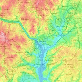
Nome: Mappa topografica Washington, D.C., altitudine, rilievo.
Altitudine media: 63 m
Altitudine minima: -2 m
Altitudine massima: 161 m
The highest natural elevation in the District is 409 feet (125 m) above sea level at Fort Reno Park in upper northwest Washington. The lowest point is sea level at the Potomac River. The geographic center of Washington is near the intersection of 4th and L Streets NW.