
Fai una donazione
Preparati per la tua prossima avventura:
In qualità di associato Amazon, questo sito riceve una commissione sugli acquisti idonei senza alcun costo aggiuntivo per te.
Mappa topografica Branderschrofen
Clicca sulla mappa per visualizzare l'altitudine.
Fai una donazione
Preparati per la tua prossima avventura:
In qualità di associato Amazon, questo sito riceve una commissione sugli acquisti idonei senza alcun costo aggiuntivo per te.
A proposito di questa mappa
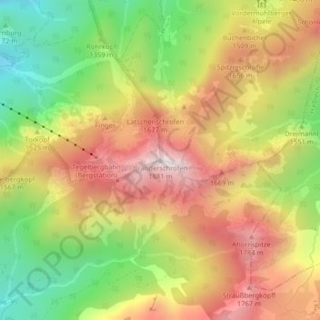
Nome: Mappa topografica Branderschrofen, altitudine, rilievo.
Altitudine media: 1.423 m
Altitudine minima: 966 m
Altitudine massima: 1.860 m
Fai una donazione
Preparati per la tua prossima avventura:
In qualità di associato Amazon, questo sito riceve una commissione sugli acquisti idonei senza alcun costo aggiuntivo per te.
Altre mappe topografiche
Clicca su una mappa per visualizzarne la topografia, l'altitudine e il rilievo.
Forggensee
Deutschland > Bayern > Landkreis Ostallgäu > Schwangau
Nach dem Höhepunkt der letzten Eiszeit schmolz der das ganze Ostallgäu bedeckende Lech-Wertach-Vorlandgletscher allmählich wieder von seinem Maximalstand bei Kaufbeuren zurück, wobei sich, wie im gesamten Voralpenbereich, am Rand der Gletscherzunge bei zwischenzeitlichen Stockungen oder erneutem Wachsen…
Altitudine media: 821 m