
Fai una donazione
Preparati per la tua prossima avventura:
In qualità di associato Amazon, questo sito riceve una commissione sugli acquisti idonei senza alcun costo aggiuntivo per te.
Mappa topografica Yerington
Clicca sulla mappa per visualizzare l'altitudine.
Fai una donazione
Preparati per la tua prossima avventura:
In qualità di associato Amazon, questo sito riceve una commissione sugli acquisti idonei senza alcun costo aggiuntivo per te.
Yerington
During the summer, temperatures are generally hot to very hot in the afternoon, but the high altitude and low humidity means temperature drop to a comfortable level at night. On average, 8.0 afternoons each summer will exceed 100 °F or 37.8 °C and 73.2 afternoons reach 90 °F (32.2 °C). It is rare, though, that minima stay above 68 °F (20.0 °C), although thirteen mornings stayed this warm in 2015. The hottest minimum has been 78 °F (25.6 °C) on July 22, 2003, and the hottest temperature 107 °F (41.7 °C) on July 15, 2014. In the winter, afternoons are sunny and cool to cold with all but 4.6 topping freezing on average, although mornings typically range from freezing to frigid: 135.5 mornings fall below freezing in an average year and 0.6 fall to or below 0 °F (−17.8 °C). The coldest temperature on record is −26 °F (−32.2 °C) on January 21, 1937, and the coldest month January 1949 which averaged 12.4 °F (−10.9 °C) with a mean minimum of −4.6 °F (−20.3 °C). The coldest afternoon is 6 °F (−14.4 °C), which occurred on February 6, 1989, and December 22, 1990.
Fai una donazione
Preparati per la tua prossima avventura:
In qualità di associato Amazon, questo sito riceve una commissione sugli acquisti idonei senza alcun costo aggiuntivo per te.
A proposito di questa mappa
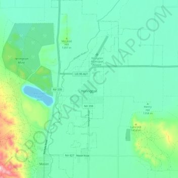
Nome: Mappa topografica Yerington, altitudine, rilievo.
Luogo: Yerington, Lyon County, Nevada, 89447, United States (38.94313 -119.18948 39.02976 -119.11681)
Altitudine media: 1.358 m
Altitudine minima: 1.281 m
Altitudine massima: 1.640 m
Fai una donazione
Preparati per la tua prossima avventura:
In qualità di associato Amazon, questo sito riceve una commissione sugli acquisti idonei senza alcun costo aggiuntivo per te.
Altre mappe topografiche
Clicca su una mappa per visualizzarne la topografia, l'altitudine e il rilievo.
Mound House
United States > Nevada > Lyon County
Mound House is a small unincorporated community in Lyon County, Nevada on U.S. Route 50 that is situated between Nevada's capital, Carson City, and Dayton. Its elevation is 4,974 feet (1,516 m). It is in Lyon County, one of eight Nevada counties that allow for legalized prostitution, and is home to four…
Altitudine media: 1.521 m
Fai una donazione
Preparati per la tua prossima avventura:
In qualità di associato Amazon, questo sito riceve una commissione sugli acquisti idonei senza alcun costo aggiuntivo per te.