
Fai una donazione
Preparati per la tua prossima avventura:
In qualità di associato Amazon, questo sito riceve una commissione sugli acquisti idonei senza alcun costo aggiuntivo per te.
Mappa topografica Carlin
Clicca sulla mappa per visualizzare l'altitudine.
Fai una donazione
Preparati per la tua prossima avventura:
In qualità di associato Amazon, questo sito riceve una commissione sugli acquisti idonei senza alcun costo aggiuntivo per te.
Carlin
Carlin is a city in Elko County of northeast Nevada, United States, and 23 miles (37 km) west of the city of Elko. As of the 2010 census, its population was 2,368, up from 2,161 at the 2000 census. Carlin sits along Interstate 80 at an elevation of approximately 4,900 feet (1,500 m). The city was named for Civil War general William Passmore Carlin. Its slogan is "Where the Train Stops...And the Gold Rush Begins".
Fai una donazione
Preparati per la tua prossima avventura:
In qualità di associato Amazon, questo sito riceve una commissione sugli acquisti idonei senza alcun costo aggiuntivo per te.
A proposito di questa mappa
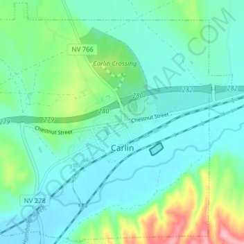
Nome: Mappa topografica Carlin, altitudine, rilievo.
Luogo: Carlin, Elko County, Nevada, 89822, United States (40.69421 -116.14234 40.74197 -116.07805)
Altitudine media: 1.522 m
Altitudine minima: 1.488 m
Altitudine massima: 1.643 m
Fai una donazione
Preparati per la tua prossima avventura:
In qualità di associato Amazon, questo sito riceve una commissione sugli acquisti idonei senza alcun costo aggiuntivo per te.
Altre mappe topografiche
Clicca su una mappa per visualizzarne la topografia, l'altitudine e il rilievo.
Ruby Mountains
United States > Nevada > Elko County
The Ruby Mountains (Shoshoni: 'Duka Doya', meaning “Snowcapped”) are a mountain range, primarily located within Elko County with a small extension into White Pine County, in Nevada, United States. Most of the range is included within the Humboldt-Toiyabe National Forest. The range reaches a maximum…
Altitudine media: 1.962 m
Fai una donazione
Preparati per la tua prossima avventura:
In qualità di associato Amazon, questo sito riceve una commissione sugli acquisti idonei senza alcun costo aggiuntivo per te.
Jackpot
United States > Nevada > Elko County
In addition to its casino industry, Jackpot has its own schools, golf course, and post office. Its elevation is approximately 5,200 feet (1,580 m) above sea level.
Altitudine media: 1.635 m
Fai una donazione
Preparati per la tua prossima avventura:
In qualità di associato Amazon, questo sito riceve una commissione sugli acquisti idonei senza alcun costo aggiuntivo per te.
Fai una donazione
Preparati per la tua prossima avventura:
In qualità di associato Amazon, questo sito riceve una commissione sugli acquisti idonei senza alcun costo aggiuntivo per te.
Fai una donazione
Preparati per la tua prossima avventura:
In qualità di associato Amazon, questo sito riceve una commissione sugli acquisti idonei senza alcun costo aggiuntivo per te.
Fai una donazione
Preparati per la tua prossima avventura:
In qualità di associato Amazon, questo sito riceve una commissione sugli acquisti idonei senza alcun costo aggiuntivo per te.