
Mappa topografica Falcon Lake
Clicca sulla mappa per visualizzare l'altitudine.
A proposito di questa mappa
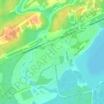
Nome: Mappa topografica Falcon Lake, altitudine, rilievo.
Luogo: Falcon Lake, Manitoba, Canada (49.67768 -95.34190 49.69768 -95.32190)
Altitudine media: 336 m
Altitudine minima: 322 m
Altitudine massima: 360 m
Altre mappe topografiche
Clicca su una mappa per visualizzarne la topografia, l'altitudine e il rilievo.
Winnipeg
Winnipeg lies at the bottom of the Red River Valley, a flood plain with an extremely flat topography. It is on the eastern edge of the Canadian Prairies in Western Canada and is known as the "Gateway to the West". Winnipeg is bordered by tallgrass prairie to the west and south and the aspen parkland to the…
Altitudine media: 236 m
Duck Mountain Provincial Park
Canada > Manitoba > Unorganized Division No. 20 (South)
Altitudine media: 656 m
West Shoal Lake
Canada > Manitoba > Division No. 18 > Rural Municipality of St. Laurent
Altitudine media: 262 m