
Fai una donazione
Preparati per la tua prossima avventura:
In qualità di associato Amazon, questo sito riceve una commissione sugli acquisti idonei senza alcun costo aggiuntivo per te.
Mappa topografica Mountain City
Clicca sulla mappa per visualizzare l'altitudine.
Fai una donazione
Preparati per la tua prossima avventura:
In qualità di associato Amazon, questo sito riceve una commissione sugli acquisti idonei senza alcun costo aggiuntivo per te.
Mountain City
Mountain City is an incorporated town in Rabun County, Georgia, United States. The population was 904 at the 2020 census. The town straddles the Eastern Continental Divide in a deep gap in the Blue Ridge Mountain front. The gap allows U.S. Route 441 to cross the range at an elevation of 2168 feet without the significant grade required by roadways at most other mountain passes along the Georgia Blue Ridge.
Fai una donazione
Preparati per la tua prossima avventura:
In qualità di associato Amazon, questo sito riceve una commissione sugli acquisti idonei senza alcun costo aggiuntivo per te.
A proposito di questa mappa
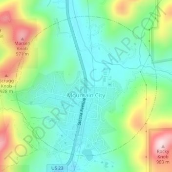
Nome: Mappa topografica Mountain City, altitudine, rilievo.
Luogo: Mountain City, Rabun County, Georgia, 30562, United States (34.90855 -83.39892 34.93057 -83.37193)
Altitudine media: 747 m
Altitudine minima: 635 m
Altitudine massima: 985 m
Fai una donazione
Preparati per la tua prossima avventura:
In qualità di associato Amazon, questo sito riceve una commissione sugli acquisti idonei senza alcun costo aggiuntivo per te.
Altre mappe topografiche
Clicca su una mappa per visualizzarne la topografia, l'altitudine e il rilievo.
Fai una donazione
Preparati per la tua prossima avventura:
In qualità di associato Amazon, questo sito riceve una commissione sugli acquisti idonei senza alcun costo aggiuntivo per te.
Clayton
United States > Georgia > Rabun County > Clayton
According to the United States Census Bureau, the city has a total area of 3.1 square miles (8.0 km2), all of it land. The elevation of Clayton's downtown area is 1,925 feet (587 m). A number of hilltops within the city limits exceed 2,200 feet.
Altitudine media: 634 m
Fai una donazione
Preparati per la tua prossima avventura:
In qualità di associato Amazon, questo sito riceve una commissione sugli acquisti idonei senza alcun costo aggiuntivo per te.