
Fai una donazione
Preparati per la tua prossima avventura:
In qualità di associato Amazon, questo sito riceve una commissione sugli acquisti idonei senza alcun costo aggiuntivo per te.
Mappa topografica Lava Dome
Clicca sulla mappa per visualizzare l'altitudine.
Fai una donazione
Preparati per la tua prossima avventura:
In qualità di associato Amazon, questo sito riceve una commissione sugli acquisti idonei senza alcun costo aggiuntivo per te.
A proposito di questa mappa
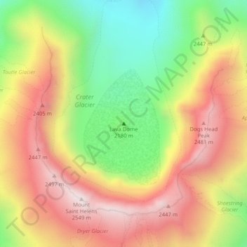
Nome: Mappa topografica Lava Dome, altitudine, rilievo.
Luogo: Lava Dome, Skamania County, Washington, United States (46.19960 -122.18889 46.19970 -122.18879)
Altitudine media: 2.109 m
Altitudine minima: 1.658 m
Altitudine massima: 2.533 m
Fai una donazione
Preparati per la tua prossima avventura:
In qualità di associato Amazon, questo sito riceve una commissione sugli acquisti idonei senza alcun costo aggiuntivo per te.
Altre mappe topografiche
Clicca su una mappa per visualizzarne la topografia, l'altitudine e il rilievo.
North Bonneville
United States > Washington > Skamania County > North Bonneville
Altitudine media: 201 m
Spirit Lake
United States > Washington > Skamania County
Prior to 1980, Spirit Lake consisted of two arms that occupied what had been the valleys of the North Fork Toutle River and a tributary. About 4,000 years ago, these valleys were blocked by lahars and pyroclastic flow deposits from Mount St. Helens to form the pre-1980 Spirit Lake. The longest branch of Spirit…
Altitudine media: 1.144 m
Fai una donazione
Preparati per la tua prossima avventura:
In qualità di associato Amazon, questo sito riceve una commissione sugli acquisti idonei senza alcun costo aggiuntivo per te.
Indian Heaven Wilderness
United States > Washington > Skamania County
Lava once flowed from the numerous volcanic cones that rise above the plateau, consisting mainly of overlapping shield volcanoes, spatter cones, and cinder cones, which averages 4,500 feet (1,400 m) in elevation. The wilderness' highest point is Lemei Rock (5,927 ft), whose crater now contains Lake Wapiki.…
Altitudine media: 1.191 m