
Mappa topografica Goshen
Mappa interattiva
Clicca sulla mappa per visualizzare l'altitudine.
A proposito di questa mappa
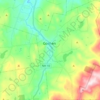
Nome: Mappa topografica Goshen, altitudine, rilievo.
Luogo: Goshen, Sullivan County, New Hampshire, 03752, United States (43.24895 -72.16550 43.34080 -72.06328)
Altitudine media: 419 m
Altitudine minima: 249 m
Altitudine massima: 765 m
The long ridge of Mount Sunapee occupies the eastern edge of town. The highest point in Goshen is an unnamed knob on the ridge (near Goves Mountain) where the elevation reaches 2,529 feet (771 m) above sea level.