
Fai una donazione
Preparati per la tua prossima avventura:
In qualità di associato Amazon, questo sito riceve una commissione sugli acquisti idonei senza alcun costo aggiuntivo per te.
Mappa topografica Sandia Mountain Wilderness
Clicca sulla mappa per visualizzare l'altitudine.
Fai una donazione
Preparati per la tua prossima avventura:
In qualità di associato Amazon, questo sito riceve una commissione sugli acquisti idonei senza alcun costo aggiuntivo per te.
Sandia Mountain Wilderness
Some of the most common animals seen in the Sandia Wilderness are mule deer, black bears, raccoons, bobcats, and various species of squirrel. There are also many birds of prey that live and migrate within the Sandia Mountain Wilderness including golden eagles and various species of hawks. Other birds such as roadrunners, Steller's Jays, ravens, and canyon wrens can also be found on in the mountains. The upper parts of the Sandia Mountains have a lot of tree cover made up mostly of firs and spruce trees, with ponderosas and conifers inhabiting the middle elevations.
Fai una donazione
Preparati per la tua prossima avventura:
In qualità di associato Amazon, questo sito riceve una commissione sugli acquisti idonei senza alcun costo aggiuntivo per te.
A proposito di questa mappa
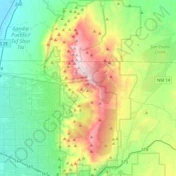
Nome: Mappa topografica Sandia Mountain Wilderness, altitudine, rilievo.
Altitudine media: 2.051 m
Altitudine minima: 1.531 m
Altitudine massima: 3.245 m
Fai una donazione
Preparati per la tua prossima avventura:
In qualità di associato Amazon, questo sito riceve una commissione sugli acquisti idonei senza alcun costo aggiuntivo per te.