
Mappa topografica Brattleboro
Clicca sulla mappa per visualizzare l'altitudine.
Brattleboro
The town's densely populated center is located near Vermont's lowest elevation point in the Connecticut river valley. Because of the surrounding steep hills there is very little flat land, and many of its buildings and houses are situated on steep hillsides, necessarily closely bunched together. This concentrated topography and population density have helped to create a semi-urban, cosmopolitan atmosphere in the downtown.
A proposito di questa mappa
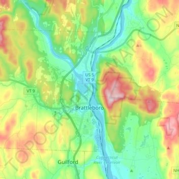
Nome: Mappa topografica Brattleboro, altitudine, rilievo.
Luogo: Brattleboro, Windham County, Vermont, United States (42.82400 -72.68063 42.89966 -72.53225)
Altitudine media: 184 m
Altitudine minima: 60 m
Altitudine massima: 412 m
Altre mappe topografiche
Clicca su una mappa per visualizzarne la topografia, l'altitudine e il rilievo.
Bellows Falls
United States > Vermont > Windham County > Rockingham > Bellows Falls
Altitudine media: 161 m
Wilmington
United States > Vermont > Windham County > Wilmington > Wilmington
Wilmington experiences a humid continental climate (Koppen Dfb) with warm, humid summers and cold (sometimes severely cold) winters. While snowfall can vary greatly from year to year in nearby towns like Bennington and Brattleboro, Wilmington's snowfall is consistently heavy each year because of its elevation…
Altitudine media: 515 m