
Fai una donazione
Preparati per la tua prossima avventura:
In qualità di associato Amazon, questo sito riceve una commissione sugli acquisti idonei senza alcun costo aggiuntivo per te.
Mappa topografica Wesser
Clicca sulla mappa per visualizzare l'altitudine.
Fai una donazione
Preparati per la tua prossima avventura:
In qualità di associato Amazon, questo sito riceve una commissione sugli acquisti idonei senza alcun costo aggiuntivo per te.
A proposito di questa mappa
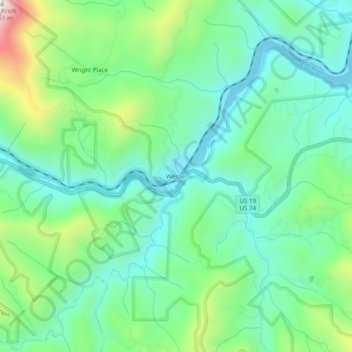
Nome: Mappa topografica Wesser, altitudine, rilievo.
Luogo: Wesser, Swain County, North Carolina, United States (35.31324 -83.61140 35.35324 -83.57140)
Altitudine media: 672 m
Altitudine minima: 503 m
Altitudine massima: 1.114 m
Fai una donazione
Preparati per la tua prossima avventura:
In qualità di associato Amazon, questo sito riceve una commissione sugli acquisti idonei senza alcun costo aggiuntivo per te.
Altre mappe topografiche
Clicca su una mappa per visualizzarne la topografia, l'altitudine e il rilievo.
Fontana Lake
United States > North Carolina > Swain County
Fontana Lake provides the only access into the most remote areas of the National Park, unless visitors undertake a multi-day hike to get there. When the lake is at the normal summer level, a boat may be used to access remote trailheads such as Hazel Creek. From the observation tower on Kuwohi, on a clear day…
Altitudine media: 806 m
Fontana Dam
United States > North Carolina > Swain County
Fontana Dam is 2,365 feet (721 m) long and 480 feet (146 m) high, making it the tallest dam in the Eastern United States. The dam has a flood storage capacity of 513,965 acre-feet (633,966,000 m3), and the combined capacity of its three generators is 293.6 megawatts. Fontana Lake has 238 miles (383 km) of…
Altitudine media: 525 m
Oconaluftee River
United States > North Carolina > Swain County > Yellowhill Community
Altitudine media: 922 m
Fai una donazione
Preparati per la tua prossima avventura:
In qualità di associato Amazon, questo sito riceve una commissione sugli acquisti idonei senza alcun costo aggiuntivo per te.