
Fai una donazione
Preparati per la tua prossima avventura:
In qualità di associato Amazon, questo sito riceve una commissione sugli acquisti idonei senza alcun costo aggiuntivo per te.
Mappa topografica Statesville
Clicca sulla mappa per visualizzare l'altitudine.
Fai una donazione
Preparati per la tua prossima avventura:
In qualità di associato Amazon, questo sito riceve una commissione sugli acquisti idonei senza alcun costo aggiuntivo per te.
Statesville
Statesville has a humid subtropical climate (Cfa) like most of the state of North Carolina, although its higher elevation leads to cooler temperatures than much of the Piedmont. Summers are generally hot and humid, with mild nights, while winters are usually cool with chilly nights and sporadic snowfall. Severe thunderstorms can be an issue during summer, with wind speeds of 60 mph and even gusts of 95 mph being recorded during these storms.
Fai una donazione
Preparati per la tua prossima avventura:
In qualità di associato Amazon, questo sito riceve una commissione sugli acquisti idonei senza alcun costo aggiuntivo per te.
A proposito di questa mappa
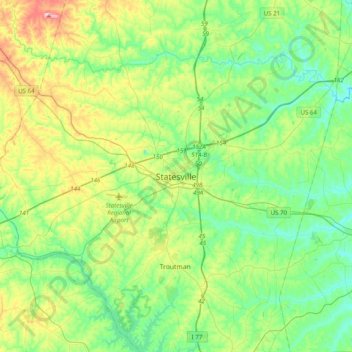
Nome: Mappa topografica Statesville, altitudine, rilievo.
Altitudine media: 266 m
Altitudine minima: 206 m
Altitudine massima: 415 m
Fai una donazione
Preparati per la tua prossima avventura:
In qualità di associato Amazon, questo sito riceve una commissione sugli acquisti idonei senza alcun costo aggiuntivo per te.