
Fai una donazione
Preparati per la tua prossima avventura:
In qualità di associato Amazon, questo sito riceve una commissione sugli acquisti idonei senza alcun costo aggiuntivo per te.
Mappa topografica Steptoe Valley
Clicca sulla mappa per visualizzare l'altitudine.
Fai una donazione
Preparati per la tua prossima avventura:
In qualità di associato Amazon, questo sito riceve una commissione sugli acquisti idonei senza alcun costo aggiuntivo per te.
A proposito di questa mappa
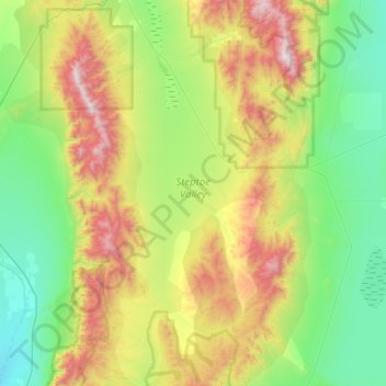
Nome: Mappa topografica Steptoe Valley, altitudine, rilievo.
Luogo: Steptoe Valley, White Pine County, Nevada, United States (38.75810 -114.89533 39.23234 -114.66860)
Altitudine media: 2.142 m
Altitudine minima: 1.650 m
Altitudine massima: 3.291 m
Fai una donazione
Preparati per la tua prossima avventura:
In qualità di associato Amazon, questo sito riceve una commissione sugli acquisti idonei senza alcun costo aggiuntivo per te.
Altre mappe topografiche
Clicca su una mappa per visualizzarne la topografia, l'altitudine e il rilievo.
Ely
United States > Nevada > White Pine County
Ely experiences a semi-arid climate (Köppen BSk), and extreme day-night temperature differences year-round. Ely's nighttime temperatures account for it being listed as one of the coldest places in the contiguous United States, with an average of 214.9 nights per year with a minimum temperature of 32 °F (0…
Altitudine media: 2.045 m
Snake Range
United States > Nevada > White Pine County
The Snake Range is a mountain range in White Pine County, Nevada, United States. The south-central portion of the range is included within Great Basin National Park, with most of the remainder included within the Humboldt-Toiyabe National Forest. The range reaches a maximum elevation of 13,065 feet (3,982 m)…
Altitudine media: 1.996 m
Great Basin National Park
United States > Nevada > White Pine County
The park derives its name from the Great Basin, the dry and mountainous region between the Sierra Nevada and the Wasatch Mountains. Topographically, this area is known as the Basin and Range Province. The park is located about 290 miles (470 km) north of Las Vegas and protects 77,180 acres (31,230 ha).
Altitudine media: 2.352 m
Fai una donazione
Preparati per la tua prossima avventura:
In qualità di associato Amazon, questo sito riceve una commissione sugli acquisti idonei senza alcun costo aggiuntivo per te.
Great Basin National Park
United States > Nevada > White Pine County
The park derives its name from the Great Basin, the dry and mountainous region between the Sierra Nevada and the Wasatch Mountains. Topographically, this area is known as the Basin and Range Province. The park is located about 290 miles (470 km) north of Las Vegas and protects 77,180 acres (31,230 ha).
Altitudine media: 2.352 m
Ely
United States > Nevada > White Pine County
Ely experiences a semi-arid climate (Köppen BSk), and extreme day-night temperature differences year-round. Ely's nighttime temperatures account for it being listed as one of the coldest places in the contiguous United States, with an average of 214.9 nights per year with a minimum temperature of 32 °F (0…
Altitudine media: 2.045 m
Fai una donazione
Preparati per la tua prossima avventura:
In qualità di associato Amazon, questo sito riceve una commissione sugli acquisti idonei senza alcun costo aggiuntivo per te.