
Fai una donazione
Preparati per la tua prossima avventura:
In qualità di associato Amazon, questo sito riceve una commissione sugli acquisti idonei senza alcun costo aggiuntivo per te.
Mappa topografica Port Charlotte
Clicca sulla mappa per visualizzare l'altitudine.
Fai una donazione
Preparati per la tua prossima avventura:
In qualità di associato Amazon, questo sito riceve una commissione sugli acquisti idonei senza alcun costo aggiuntivo per te.
Port Charlotte
Port Charlotte is characterized by a predominantly flat and low-lying terrain, typical of Florida’s coastal landscape. The area features a network of waterways, including the Peace River and Charlotte Harbor, which provide ample opportunities for recreational activities like boating and fishing. Elevations are generally modest, with the highest points rarely exceeding 30 feet above sea level. The region is dotted with numerous canals, many of which are navigable, enhancing the community's waterfront appeal. The surrounding environment includes patches of subtropical vegetation and wetlands, contributing to the area's biodiversity and scenic beauty. Overall, Port Charlotte's topography, with its gentle contours and extensive water features, creates a picturesque setting that reflects the charm of Florida's Gulf Coast.
Fai una donazione
Preparati per la tua prossima avventura:
In qualità di associato Amazon, questo sito riceve una commissione sugli acquisti idonei senza alcun costo aggiuntivo per te.
A proposito di questa mappa
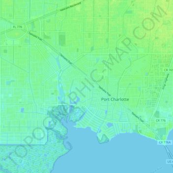
Nome: Mappa topografica Port Charlotte, altitudine, rilievo.
Luogo: Port Charlotte, Charlotte County, Florida, United States (26.94693 -82.15629 27.01802 -82.05760)
Altitudine media: 4 m
Altitudine minima: -2 m
Altitudine massima: 10 m
Fai una donazione
Preparati per la tua prossima avventura:
In qualità di associato Amazon, questo sito riceve una commissione sugli acquisti idonei senza alcun costo aggiuntivo per te.
Altre mappe topografiche
Clicca su una mappa per visualizzarne la topografia, l'altitudine e il rilievo.
Punta Gorda
United States > Florida > Charlotte County
Punta Gorda features a predominantly flat topography characterized by its low elevation, averaging around 7 to 10 feet above sea level. The terrain is primarily made up of coastal plains and wetlands, interspersed with small hills such as those found in South Punta Gorda Heights, which can reach elevations of…
Altitudine media: 3 m
Fai una donazione
Preparati per la tua prossima avventura:
In qualità di associato Amazon, questo sito riceve una commissione sugli acquisti idonei senza alcun costo aggiuntivo per te.
Fai una donazione
Preparati per la tua prossima avventura:
In qualità di associato Amazon, questo sito riceve una commissione sugli acquisti idonei senza alcun costo aggiuntivo per te.
Punta Gorda Isles
United States > Florida > Charlotte County > Punta Gorda > Punta Gorda Isles
Altitudine media: 2 m
Fai una donazione
Preparati per la tua prossima avventura:
In qualità di associato Amazon, questo sito riceve una commissione sugli acquisti idonei senza alcun costo aggiuntivo per te.
Fai una donazione
Preparati per la tua prossima avventura:
In qualità di associato Amazon, questo sito riceve una commissione sugli acquisti idonei senza alcun costo aggiuntivo per te.
South Punta Gorda Heights
United States > Florida > Charlotte County > Punta Gorda
Altitudine media: 8 m
Fai una donazione
Preparati per la tua prossima avventura:
In qualità di associato Amazon, questo sito riceve una commissione sugli acquisti idonei senza alcun costo aggiuntivo per te.
Fai una donazione
Preparati per la tua prossima avventura:
In qualità di associato Amazon, questo sito riceve una commissione sugli acquisti idonei senza alcun costo aggiuntivo per te.
Fai una donazione
Preparati per la tua prossima avventura:
In qualità di associato Amazon, questo sito riceve una commissione sugli acquisti idonei senza alcun costo aggiuntivo per te.
Placida
United States > Florida > Charlotte County
Placida is located at 26°49′55″N 82°15′54″W / 26.83194°N 82.265°W / 26.83194; -82.265Coordinates: 26°49′55″N 82°15′54″W / 26.83194°N 82.265°W / 26.83194; -82.265 (26.83194, -82.265). Placida has an elevation of 3 feet.
Altitudine media: 1 m
Fai una donazione
Preparati per la tua prossima avventura:
In qualità di associato Amazon, questo sito riceve una commissione sugli acquisti idonei senza alcun costo aggiuntivo per te.