
Mappa topografica Rogersville
Mappa interattiva
Clicca sulla mappa per visualizzare l'altitudine.
A proposito di questa mappa
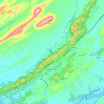
Nome: Mappa topografica Rogersville, altitudine, rilievo.
Altitudine media: 416 m
Altitudine minima: 324 m
Altitudine massima: 716 m
Rogersville is located slightly southwest of the center of Hawkins County. According to the United States Census Bureau, the town has a total area of 3.4 square miles (8.8 km2), all land. The town is in the valley of Crockett Creek, a southwest-flowing tributary of the Holston River. The elevation of Rogersville is 1,286 feet (392 m). Via U.S. Route 11W (see below), it is 28 miles (45 km) southwest of Kingsport and 65 miles (105 km) northeast of Knoxville.