
Fai una donazione
Preparati per la tua prossima avventura:
In qualità di associato Amazon, questo sito riceve una commissione sugli acquisti idonei senza alcun costo aggiuntivo per te.
Mappa topografica Ojén
Clicca sulla mappa per visualizzare l'altitudine.
Fai una donazione
Preparati per la tua prossima avventura:
In qualità di associato Amazon, questo sito riceve una commissione sugli acquisti idonei senza alcun costo aggiuntivo per te.
Ojén
The town is situated beside the Almadán stream above the valley of the River Real at an altitude of approximately 200 metres, hemmed in by the Sierra Blanca and the Sierra Alpujata. These may provide a clue to the Moors' determination to stay in spite of their apparent antipathy, for both ranges of mountains have long been known as rich sources of talc, nickel, iron and lead. This mineral wealth put the area in the forefront of the Spanish industrial revolution of the 19th century.
Fai una donazione
Preparati per la tua prossima avventura:
In qualità di associato Amazon, questo sito riceve una commissione sugli acquisti idonei senza alcun costo aggiuntivo per te.
A proposito di questa mappa
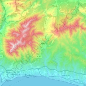
Nome: Mappa topografica Ojén, altitudine, rilievo.
Luogo: Ojén, Sierra de las Nieves, Malaga, Andalusia, 29610, Spain (36.52108 -4.92218 36.60949 -4.73540)
Altitudine media: 404 m
Altitudine minima: -1 m
Altitudine massima: 1.254 m
Fai una donazione
Preparati per la tua prossima avventura:
In qualità di associato Amazon, questo sito riceve una commissione sugli acquisti idonei senza alcun costo aggiuntivo per te.