
Mappa topografica Zagreb
Mappa interattiva
Clicca sulla mappa per visualizzare l'altitudine.
A proposito di questa mappa
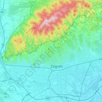
Nome: Mappa topografica Zagreb, altitudine, rilievo.
Luogo: Zagreb, City of Zagreb, Croatia (45.74733 15.82174 45.93800 16.10710)
Altitudine media: 251 m
Altitudine minima: 99 m
Altitudine massima: 1.027 m
Zagreb (/ˈzɑːɡrɛb, ˈzæɡrɛb, zɑːˈɡrɛb/ ZAH-greb, ZAG-reb, zah-GREB; Croatian pronunciation: (listen)) is the capital and the largest city of Croatia. It is in the northwest of the country, along the Sava river, at the southern slopes of the Medvednica mountain. Zagreb lies at an elevation of approximately 122 m (400 ft) above sea level. The estimated population of the city in 2018 was 804,507. The population of the Zagreb urban agglomeration is 1,086,528, approximately a quarter of the total population of Croatia.
Altre mappe topografiche
Clicca su una mappa per visualizzarne la topografia, l'altitudine e il rilievo.
Trešnjevka - sjever
Trešnjevka - sjever, Zagreb, City of Zagreb, 10110, Croatia
Altitudine media: 129 m