
Fai una donazione
Preparati per la tua prossima avventura:
In qualità di associato Amazon, questo sito riceve una commissione sugli acquisti idonei senza alcun costo aggiuntivo per te.
Mappa topografica Morehead
Clicca sulla mappa per visualizzare l'altitudine.
Fai una donazione
Preparati per la tua prossima avventura:
In qualità di associato Amazon, questo sito riceve una commissione sugli acquisti idonei senza alcun costo aggiuntivo per te.
Morehead
Morehead is in the foothills of the Appalachian Mountains. The topography of the area represents a mixture of the Highland Rim and the western border of the Eastern Kentucky Coalfield. The highest elevation in the county is Limestone Knob (1435 ft), situated approximately 3 miles southwest of Morehead. The elevation of the city is 748 ft.
Fai una donazione
Preparati per la tua prossima avventura:
In qualità di associato Amazon, questo sito riceve una commissione sugli acquisti idonei senza alcun costo aggiuntivo per te.
A proposito di questa mappa
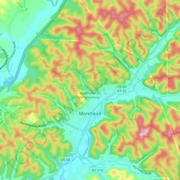
Nome: Mappa topografica Morehead, altitudine, rilievo.
Luogo: Morehead, Rowan County, Kentucky, 40351, United States (38.16309 -83.49611 38.22257 -83.40844)
Altitudine media: 287 m
Altitudine minima: 207 m
Altitudine massima: 413 m
Fai una donazione
Preparati per la tua prossima avventura:
In qualità di associato Amazon, questo sito riceve una commissione sugli acquisti idonei senza alcun costo aggiuntivo per te.
Altre mappe topografiche
Clicca su una mappa per visualizzarne la topografia, l'altitudine e il rilievo.
Fai una donazione
Preparati per la tua prossima avventura:
In qualità di associato Amazon, questo sito riceve una commissione sugli acquisti idonei senza alcun costo aggiuntivo per te.