
Fai una donazione
Preparati per la tua prossima avventura:
In qualità di associato Amazon, questo sito riceve una commissione sugli acquisti idonei senza alcun costo aggiuntivo per te.
Mappa topografica Herkimer
Clicca sulla mappa per visualizzare l'altitudine.
Fai una donazione
Preparati per la tua prossima avventura:
In qualità di associato Amazon, questo sito riceve una commissione sugli acquisti idonei senza alcun costo aggiuntivo per te.
Herkimer
In 1722, in response to a request by the German Palatine leaders Joseph Petrie and Conrad Rickert, Governor William Burnet granted the Palatines a lease to purchase land from the Mohawk Nation in the vicinity of the confluence of West Canada Creek and the Mohawk River. After a survey of the land was completed in 1723, many more settlers arrived in the area between 1723 and 1725. They settled on both the north and south sides of the Mohawk River. The area was originally known as "Burnetsfield", named in honor of the governor. The Burnetsfield Patent, granted April 13, 1725, assigned 100-acre (0.40 km2) lots to about ninety heads of family. The area was also referred to at times as "Stone Ridge", "The Flats", "The Falls", and most commonly, due to the mostly German immigrant population and the flat floodplain topography, as German Flatts. This was the first European-American settlement this far west in the Mohawk Valley.
Fai una donazione
Preparati per la tua prossima avventura:
In qualità di associato Amazon, questo sito riceve una commissione sugli acquisti idonei senza alcun costo aggiuntivo per te.
A proposito di questa mappa
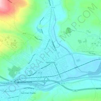
Nome: Mappa topografica Herkimer, altitudine, rilievo.
Altitudine media: 154 m
Altitudine minima: 110 m
Altitudine massima: 325 m
Fai una donazione
Preparati per la tua prossima avventura:
In qualità di associato Amazon, questo sito riceve una commissione sugli acquisti idonei senza alcun costo aggiuntivo per te.