

Mappa topografica Crestone Peak
Clicca sulla mappa per visualizzare l'altitudine.
Crestone Peak
Generally climbs of Crestone Peak or Crestone Needle start from a base camp at South Colony Lakes, east of the peak, accessed from the Wet Mountain Valley on the northeast side of the range. This route involves nearly 6,000 ft (1,800 m) of elevation gain, and ascends to a large relatively flat area called "The Pool Table" (a few large rocks lie on the tundra, as if billiard balls) or the "Bears' Playground." Then it ascends a long gully on the northwest side of Crestone Peak, which involves some rockfall danger (hence a climbing helmet is suggested). Crestone Peak is one of the more dangerous fourteener climbs in Colorado; accidents occur often in the Crestones, some caused by falls or lightning (a daily summer occurrence in the Sangre de Cristos).
A proposito di questa mappa
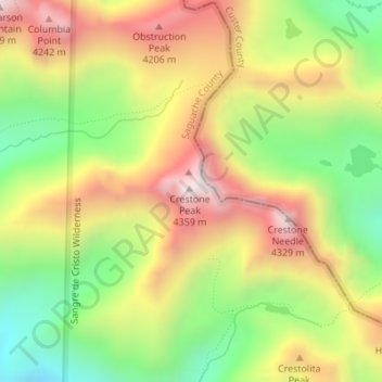
Nome: Mappa topografica Crestone Peak, altitudine, rilievo.
Luogo: Crestone Peak, Saguache County, Colorado, United States (37.96683 -105.58550 37.96693 -105.58540)
Altitudine media: 3.875 m
Altitudine minima: 3.443 m
Altitudine massima: 4.339 m
Altre mappe topografiche
Clicca su una mappa per visualizzarne la topografia, l'altitudine e il rilievo.
Great Sand Dunes National Park
United States > Colorado > Saguache County
In 1848, John C. Frémont was hired to find a railroad route from St. Louis to California. He crossed the Sangre de Cristos into the San Luis Valley in winter, courting disaster but proving that a winter crossing of this range was possible. He was followed in 1853 by Captain John Gunnison of the Corps of…
Altitudine media: 2.616 m
Great Sand Dunes National Preserve
United States > Colorado > Saguache County
In 1848, John C. Frémont was hired to find a railroad route from St. Louis to California. He crossed the Sangre de Cristos into the San Luis Valley in winter, courting disaster but proving that a winter crossing of this range was possible. He was followed in 1853 by Captain John Gunnison of the Corps of…
Altitudine media: 2.792 m

Great Sand Dunes National Park
United States > Colorado > Saguache County
In 1848, John C. Frémont was hired to find a railroad route from St. Louis to California. He crossed the Sangre de Cristos into the San Luis Valley in winter, courting disaster but proving that a winter crossing of this range was possible. He was followed in 1853 by Captain John Gunnison of the Corps of…
Altitudine media: 2.616 m