
Fai una donazione
Preparati per la tua prossima avventura:
In qualità di associato Amazon, questo sito riceve una commissione sugli acquisti idonei senza alcun costo aggiuntivo per te.
Mappa topografica Highland Springs
Clicca sulla mappa per visualizzare l'altitudine.
Fai una donazione
Preparati per la tua prossima avventura:
In qualità di associato Amazon, questo sito riceve una commissione sugli acquisti idonei senza alcun costo aggiuntivo per te.
Highland Springs
The Highland Springs are 5 miles (8.0 km) southwest of Kelseyville. They are in the edge of the mountains that border the flat Big Valley area to the west of Clear Lake (California). It is at an elevation of 1483 feet (452 m). OpenStreetMap shows the Old Toll Road branching off to the southeast from the Lakeport–Hopland Road (CA175) just east of Hopland. The road turns east, and when it passes from Mendocino County to Lake County it changes name to Highland Springs Road. It continues east through Highland Springs, then turns north past Highland Springs Reservoir to join CA29 / CA175 just east of Lampson Field and south of Lakeport.
Fai una donazione
Preparati per la tua prossima avventura:
In qualità di associato Amazon, questo sito riceve una commissione sugli acquisti idonei senza alcun costo aggiuntivo per te.
A proposito di questa mappa
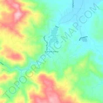
Nome: Mappa topografica Highland Springs, altitudine, rilievo.
Luogo: Highland Springs, Lake County, California, United States (38.91712 -122.92694 38.95712 -122.88694)
Altitudine media: 514 m
Altitudine minima: 428 m
Altitudine massima: 664 m
Fai una donazione
Preparati per la tua prossima avventura:
In qualità di associato Amazon, questo sito riceve una commissione sugli acquisti idonei senza alcun costo aggiuntivo per te.