
Mappa topografica Arrah
Clicca sulla mappa per visualizzare l'altitudine.
Arrah
Arrah is located at the elevation of 192 m from the sea level at the bank of Son river, Ganga River and Gangi River. Arrah lies at the confluence of the Ganga and the Son River, other small rivers that flow in the town are Gangi River, Badki Nadi and Chhotki Nadi.
A proposito di questa mappa
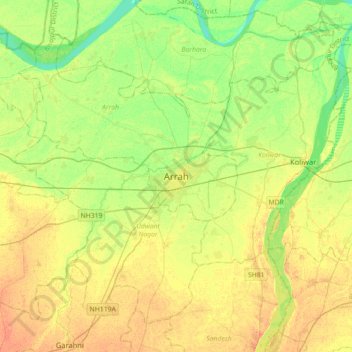
Nome: Mappa topografica Arrah, altitudine, rilievo.
Luogo: Arrah, Bhojpur, Bihar, 802300, India (25.40032 84.50321 25.72032 84.82321)
Altitudine media: 59 m
Altitudine minima: 43 m
Altitudine massima: 73 m