
Fai una donazione
Preparati per la tua prossima avventura:
In qualità di associato Amazon, questo sito riceve una commissione sugli acquisti idonei senza alcun costo aggiuntivo per te.
Mappa topografica Palaio Faliro
Clicca sulla mappa per visualizzare l'altitudine.
Fai una donazione
Preparati per la tua prossima avventura:
In qualità di associato Amazon, questo sito riceve una commissione sugli acquisti idonei senza alcun costo aggiuntivo per te.
Palaio Faliro
Phaleron was an important place in antiquity, then as now one of the demes of Athens; however, a precise definition of its Classical topography is lacking, although the location of the deme is well established. Pausanias records that it was on the coast, equidistant from Athens and Cape Kolias (i.e., Ayios Kosmas) at 20 stadia. Strabo enumerates the coastal demes east of Piraeus and starts with Phaleron. The site of the ancient town appears to be the area and headland around the church of St. George, with the harbour to the west in the open roadstead. Remains of conglomerate blocks have been found crossing the heights of Old Phaleron to the sea and these are likely to be part of the Phaleric Wall recorded by Thucydides.
Fai una donazione
Preparati per la tua prossima avventura:
In qualità di associato Amazon, questo sito riceve una commissione sugli acquisti idonei senza alcun costo aggiuntivo per te.
A proposito di questa mappa
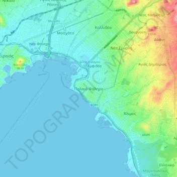
Nome: Mappa topografica Palaio Faliro, altitudine, rilievo.
Altitudine media: 27 m
Altitudine minima: -5 m
Altitudine massima: 148 m
Fai una donazione
Preparati per la tua prossima avventura:
In qualità di associato Amazon, questo sito riceve una commissione sugli acquisti idonei senza alcun costo aggiuntivo per te.
Altre mappe topografiche
Clicca su una mappa per visualizzarne la topografia, l'altitudine e il rilievo.
Municipality of Agios Dimitrios
Greece > Attica > Regional Unit of South Athens
Altitudine media: 80 m
Fai una donazione
Preparati per la tua prossima avventura:
In qualità di associato Amazon, questo sito riceve una commissione sugli acquisti idonei senza alcun costo aggiuntivo per te.