
Fai una donazione
Preparati per la tua prossima avventura:
In qualità di associato Amazon, questo sito riceve una commissione sugli acquisti idonei senza alcun costo aggiuntivo per te.
Mappa topografica Clayton
Clicca sulla mappa per visualizzare l'altitudine.
Fai una donazione
Preparati per la tua prossima avventura:
In qualità di associato Amazon, questo sito riceve una commissione sugli acquisti idonei senza alcun costo aggiuntivo per te.
Clayton
Clayton, located in the Kiamichi River valley, is framed on its west by Flagpole Mountain (1,562 ft.) and to its east by unnamed mountains topping 1,600 feet in elevation. Within a few miles of Clayton is scenic McKinley Rocks, a collection of massive boulders strewn across a mountain top. South of Clayton is Clayton Lake State Park—which is surrounded by a pine tree forest—and northwest of town is Sardis Lake, a U.S. Army Corps of Engineers dam which impounds the water of Jack's Fork Creek. The Pushmataha Wildlife Refuge is also nearby, featuring scenic views from its mountain summit.
Fai una donazione
Preparati per la tua prossima avventura:
In qualità di associato Amazon, questo sito riceve una commissione sugli acquisti idonei senza alcun costo aggiuntivo per te.
A proposito di questa mappa
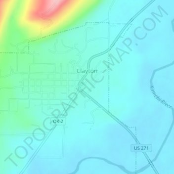
Nome: Mappa topografica Clayton, altitudine, rilievo.
Luogo: Clayton, Pushmataha County, Oklahoma, 74536, United States (34.57541 -95.37129 34.59851 -95.34265)
Altitudine media: 188 m
Altitudine minima: 162 m
Altitudine massima: 330 m
Fai una donazione
Preparati per la tua prossima avventura:
In qualità di associato Amazon, questo sito riceve una commissione sugli acquisti idonei senza alcun costo aggiuntivo per te.
Altre mappe topografiche
Clicca su una mappa per visualizzarne la topografia, l'altitudine e il rilievo.
Lost Mountain
United States > Oklahoma > Pushmataha County
The commonly accepted definition of mountain calls for a mountain's summit to top 1,000 feet in elevation. In that sense Lost Mountain qualifies as a hill.
Altitudine media: 166 m
Fai una donazione
Preparati per la tua prossima avventura:
In qualità di associato Amazon, questo sito riceve una commissione sugli acquisti idonei senza alcun costo aggiuntivo per te.