
Fai una donazione
Preparati per la tua prossima avventura:
In qualità di associato Amazon, questo sito riceve una commissione sugli acquisti idonei senza alcun costo aggiuntivo per te.
Mappa topografica Schönenberg-Kübelberg
Clicca sulla mappa per visualizzare l'altitudine.
Fai una donazione
Preparati per la tua prossima avventura:
In qualità di associato Amazon, questo sito riceve una commissione sugli acquisti idonei senza alcun costo aggiuntivo per te.
Schönenberg-Kübelberg
The municipality of Schönenberg-Kübelberg lies in the Western Palatinate near the boundary with the Saarland some 15 km south of Kusel, and 10 km northeast of Homburg. The two Ortsteile lie at the edge of the Landstuhler Bruch (a hollow). Kübelberg on the long mountain ridge south of the Klingbach runs seamlessly into Schönenberg to the east, while Schönenberg also melds without a break with the outlying centre of Sand. Within the municipality, the land rises from 241 m above sea level at the edge of the brook up to 264 m near the church in Kübelberg. Outside the built-up area, the highest elevations in the municipal area reach some 300 m above sea level in the Steinwald and Peterswald (forests).
Fai una donazione
Preparati per la tua prossima avventura:
In qualità di associato Amazon, questo sito riceve una commissione sugli acquisti idonei senza alcun costo aggiuntivo per te.
A proposito di questa mappa
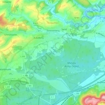
Nome: Mappa topografica Schönenberg-Kübelberg, altitudine, rilievo.
Altitudine media: 268 m
Altitudine minima: 221 m
Altitudine massima: 396 m
Fai una donazione
Preparati per la tua prossima avventura:
In qualità di associato Amazon, questo sito riceve una commissione sugli acquisti idonei senza alcun costo aggiuntivo per te.
Altre mappe topografiche
Clicca su una mappa per visualizzarne la topografia, l'altitudine e il rilievo.
Schönenberg
Germany > Rhineland-Palatinate > Landkreis Kusel > Schönenberg-Kübelberg
Altitudine media: 266 m