
Fai una donazione
Preparati per la tua prossima avventura:
In qualità di associato Amazon, questo sito riceve una commissione sugli acquisti idonei senza alcun costo aggiuntivo per te.
Mappa topografica Terry Peak
Clicca sulla mappa per visualizzare l'altitudine.
Fai una donazione
Preparati per la tua prossima avventura:
In qualità di associato Amazon, questo sito riceve una commissione sugli acquisti idonei senza alcun costo aggiuntivo per te.
A proposito di questa mappa
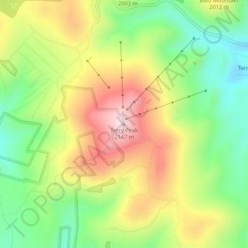
Nome: Mappa topografica Terry Peak, altitudine, rilievo.
Luogo: Terry Peak, Lawrence County, South Dakota, United States (44.32743 -103.83525 44.32753 -103.83515)
Altitudine media: 1.940 m
Altitudine minima: 1.769 m
Altitudine massima: 2.148 m
Fai una donazione
Preparati per la tua prossima avventura:
In qualità di associato Amazon, questo sito riceve una commissione sugli acquisti idonei senza alcun costo aggiuntivo per te.
Altre mappe topografiche
Clicca su una mappa per visualizzarne la topografia, l'altitudine e il rilievo.
Spearfish
United States > South Dakota > Lawrence County
Extreme winter maxima in the district are remarkably warm given the latitude and altitude; on January 19, 1921 Spearfish reached a temperature of 79 °F (26 °C), the hottest January temperature in South Dakota on record.
Altitudine media: 1.171 m
Deadwood
United States > South Dakota > Lawrence County
Deadwood is characterized by its rugged terrain nestled within the Black Hills region, boasting an elevation of approximately 4,531 feet. The town itself is set in a steep, narrow gulch surrounded by densely forested hills, which create a dramatic landscape of rolling hills and rocky outcrops. The topography…
Altitudine media: 1.511 m
Lead
United States > South Dakota > Lawrence County
Its high elevation in the Black Hills makes Lead one of the wettest places in South Dakota and among the snowiest places in the contiguous United States with a mean snowfall of 183.9 inches or 4.67 metres. During the cold and snowy winter of 1993–94, a whopping 364.7 inches (9.26 m) of snow fell and three…
Altitudine media: 1.605 m
Fai una donazione
Preparati per la tua prossima avventura:
In qualità di associato Amazon, questo sito riceve una commissione sugli acquisti idonei senza alcun costo aggiuntivo per te.
Lead
United States > South Dakota > Lawrence County
Its high elevation in the Black Hills makes Lead one of the wettest places in South Dakota and among the snowiest places in the contiguous United States with a mean snowfall of 183.9 inches or 4.67 metres. During the cold and snowy winter of 1993–94, a whopping 364.7 inches (9.26 m) of snow fell and three…
Altitudine media: 1.605 m
Spearfish
United States > South Dakota > Lawrence County
Extreme winter maxima in the district are remarkably warm given the latitude and altitude; on January 19, 1921, Spearfish reached a temperature of 79 °F (26 °C), the hottest January temperature in South Dakota on record.
Altitudine media: 1.171 m
Fai una donazione
Preparati per la tua prossima avventura:
In qualità di associato Amazon, questo sito riceve una commissione sugli acquisti idonei senza alcun costo aggiuntivo per te.