
Fai una donazione
Preparati per la tua prossima avventura:
In qualità di associato Amazon, questo sito riceve una commissione sugli acquisti idonei senza alcun costo aggiuntivo per te.
Mappa topografica Te Mata Peak
Clicca sulla mappa per visualizzare l'altitudine.
Fai una donazione
Preparati per la tua prossima avventura:
In qualità di associato Amazon, questo sito riceve una commissione sugli acquisti idonei senza alcun costo aggiuntivo per te.
Te Mata Peak
Te Mata Peak is a peak south of Hastings rising up to 399m in the Te Mata Hills in the Hawke's Bay region of New Zealand. A sealed road leads to the popular lookout at the summit, as well as many trails for hikers and mountain bikers. The Hastings suburb of Havelock North is situated at the base of the peak. Te Mata peak and the surrounding range runs in a North-East to South-West direction. The slopes on the North-Western side build up gradually. Havelock North is built upon the rolling hills at the lower extent of the ranges. The topography of the South-Eastern side has been heavily influenced by the Tukituki River, forming the Tukituki Valley. From Te Mata Peak, cliffs on the South-Eastern side drop 140 meters before extending into the rolling hills of the Tukituki Valley, making these cliffs some of the highest in the North Island of New Zealand. Their height is subject to erosion, with multiple instances of rockfall into the valley below. From the peak, large boulders can be witnessed in the valley as evidence of previous rockfall.
Fai una donazione
Preparati per la tua prossima avventura:
In qualità di associato Amazon, questo sito riceve una commissione sugli acquisti idonei senza alcun costo aggiuntivo per te.
A proposito di questa mappa
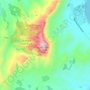
Nome: Mappa topografica Te Mata Peak, altitudine, rilievo.
Altitudine media: 144 m
Altitudine minima: 19 m
Altitudine massima: 391 m
Fai una donazione
Preparati per la tua prossima avventura:
In qualità di associato Amazon, questo sito riceve una commissione sugli acquisti idonei senza alcun costo aggiuntivo per te.