
Mappa topografica Mount Chephren
Clicca sulla mappa per visualizzare l'altitudine.
Mount Chephren
The trail head is located at the west end of the Waterfowl Lakes campground off the Icefields Parkway in Banff National Park. The elevation gain from the trail head to the summit is 1,630 m (5,348 ft).
A proposito di questa mappa
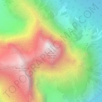
Nome: Mappa topografica Mount Chephren, altitudine, rilievo.
Altitudine media: 2.398 m
Altitudine minima: 1.689 m
Altitudine massima: 3.263 m
Altre mappe topografiche
Clicca su una mappa per visualizzarne la topografia, l'altitudine e il rilievo.
Moraine Lake
Canada > Alberta > Improvement District No. 9
Moraine Lake is a snow and glacially fed alpine lake in Banff National Park, 14 kilometres (8.7 mi) outside the village of Lake Louise, Alberta, Canada. It is situated in the Valley of the Ten Peaks, at an elevation of approximately 1,884 metres (6,181 ft). The lake has a surface area of 50 hectares (120…
Altitudine media: 2.101 m
Peyto Glacier
Canada > Alberta > Improvement District No. 9 > Area A (Kicking Horse/Kinbasket Lake)
Altitudine media: 2.641 m
Johnston Creek
Canada > Alberta > Improvement District No. 9
Johnston Creek originates north of Castle Mountain in a glacial valley southwest of Badger Pass and south of Pulsatilla Pass, at an elevation of 2,500 meters (8,200 ft). The creek flows southeast between Helena Ridge and the Sawback Range, and then south through a gorge known as Johnston Canyon. The stream…
Altitudine media: 2.135 m
Moraine Lake
Canada > Alberta > Improvement District No. 9
Moraine Lake is a snow and glacially fed alpine lake in Banff National Park, 14 kilometres (8.7 mi) outside the village of Lake Louise, Alberta, Canada. It is situated in the Valley of the Ten Peaks, at an elevation of approximately 1,884 metres (6,181 ft). The lake has a surface area of 50 hectares (120…
Altitudine media: 2.101 m
Johnston Creek
Canada > Alberta > Improvement District No. 9
Johnston Creek originates north of Castle Mountain in a glacial valley southwest of Badger Pass and south of Pulsatilla Pass, at an elevation of 2,500 meters (8,200 ft). The creek flows southeast between Helena Ridge and the Sawback Range, and then south through a gorge known as Johnston Canyon. The stream…
Altitudine media: 2.135 m