
Fai una donazione
Preparati per la tua prossima avventura:
In qualità di associato Amazon, questo sito riceve una commissione sugli acquisti idonei senza alcun costo aggiuntivo per te.
Mappa topografica Ceará
Clicca sulla mappa per visualizzare l'altitudine.
Fai una donazione
Preparati per la tua prossima avventura:
In qualità di associato Amazon, questo sito riceve una commissione sugli acquisti idonei senza alcun costo aggiuntivo per te.
Ceará
Ceará lies partly upon the northeast slope of the Brazilian Highlands, and partly upon the sandy coastal plain. Its surface is a succession of great terraces, facing north and northeast, formed by the denudation of the ancient sandstone plateau which once covered this part of the continent; the terraces are seamed by watercourses, and their valleys are broken by hills and ranges of highlands. The latter are the remains of the ancient plateau, capped with horizontal strata of sandstone, with a uniform altitude of 2,000 to 2,400 feet (610 to 730 m). The flat top of such a range is called a chapada or taboleira, and its width in places is from 32 to 56 miles (51 to 90 km). The boundary line with Piauí follows one of these ranges, the Serra de Ibiapaba, which unites with another range on the southern boundary of the state, known as the Serra do Araripe. Another range, or escarpment, crosses the state from east to west, but is broken into two principal divisions, each having several local names. These ranges are not continuous, the breaking down of the ancient plateau having been irregular and uneven.
Fai una donazione
Preparati per la tua prossima avventura:
In qualità di associato Amazon, questo sito riceve una commissione sugli acquisti idonei senza alcun costo aggiuntivo per te.
A proposito di questa mappa
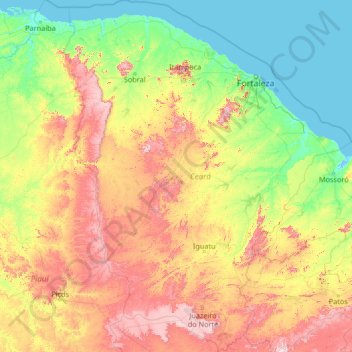
Nome: Mappa topografica Ceará, altitudine, rilievo.
Luogo: Ceará, Northeast Region, Brazil (-7.85799 -41.42350 -2.58289 -37.07848)
Altitudine media: 257 m
Altitudine minima: -3 m
Altitudine massima: 1.144 m
Fai una donazione
Preparati per la tua prossima avventura:
In qualità di associato Amazon, questo sito riceve una commissione sugli acquisti idonei senza alcun costo aggiuntivo per te.
Altre mappe topografiche
Clicca su una mappa per visualizzarne la topografia, l'altitudine e il rilievo.
Fai una donazione
Preparati per la tua prossima avventura:
In qualità di associato Amazon, questo sito riceve una commissione sugli acquisti idonei senza alcun costo aggiuntivo per te.
São Paulo
Brazil > São Paulo > Região Metropolitana de São Paulo > São Paulo
São Paulo is in Southeastern Brazil, in southeastern São Paulo State, approximately halfway between Curitiba and Rio de Janeiro. The city is on a plateau placed beyond the Serra do Mar (Portuguese for "Sea Range" or "Coastal Range"), itself a component of the vast region known as the Brazilian Highlands,…
Altitudine media: 785 m
Juami River
Juami River is a black water river, a tributary of the white water Japurá River, and runs through the Amazon plain. The entire basin of the Juami River is contained within the Juami-Japurá Ecological Station. The basin has altitudes that range from 45 to 450 metres (148 to 1,476 ft) above sea level.
Altitudine media: 109 m
Jardim São Lourenço
Brazil > São Paulo > Região Metropolitana de São Paulo > São Paulo
Altitudine media: 790 m
Fai una donazione
Preparati per la tua prossima avventura:
In qualità di associato Amazon, questo sito riceve una commissione sugli acquisti idonei senza alcun costo aggiuntivo per te.
Picado
Brazil > Bahia > Região Metropolitana de Feira de Santana > Conceição do Jacuípe
Altitudine media: 188 m
Fai una donazione
Preparati per la tua prossima avventura:
In qualità di associato Amazon, questo sito riceve una commissione sugli acquisti idonei senza alcun costo aggiuntivo per te.
Porto Alegre
Brazil > Rio Grande do Sul > Metropolitan Region of Porto Alegre > Porto Alegre
Porto Alegre has a long coastline on the Guaíba Lake, and its topography is punctuated by 40 hills. In the lake, a vast body of water, a maze of islands facing the city creates an archipelago where a unique ecosystem gives shelter to abundant wildlife. The city area concentrates 28% of the native flora of Rio…
Altitudine media: 27 m
Formosa
Brazil > Goiás > Região Integrada de Desenvolvimento do Distrito Federal e Entorno > Formosa
Altitudine media: 921 m
Fai una donazione
Preparati per la tua prossima avventura:
In qualità di associato Amazon, questo sito riceve una commissione sugli acquisti idonei senza alcun costo aggiuntivo per te.
Belo Horizonte
Brazil > Minas Gerais > Região Metropolitana de Belo Horizonte > Belo Horizonte
In 1893, due to the climatic and topographic conditions, Curral Del Rey was selected by Minas Gerais governor Afonso Pena among other cities as the location for the new economic and cultural center of the state, under the new name of Cidade de Minas, or City of Minas.
Altitudine media: 904 m
Fai una donazione
Preparati per la tua prossima avventura:
In qualità di associato Amazon, questo sito riceve una commissione sugli acquisti idonei senza alcun costo aggiuntivo per te.