
Mappa topografica Nozawaonsen
Mappa interattiva
Clicca sulla mappa per visualizzare l'altitudine.
Nozawaonsen
Nozawaonsen is located in mountainous northeastern Nagano Prefecture, about one hour's drive from Nagano City. To the south it borders Kijimadaira along the ridge of Mount Kenashi. To the west side the Chikuma River, the longest river in Japan, which forms a border of the village with the city of Iiyama. The north and the east borders Sakae village. The altitude of Nozawaonsen ranges from 300m above sea level at the lowest, to about 600m in the village, and 1,650m at the peak of Mount Kenashi.
A proposito di questa mappa
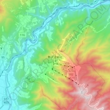
Nome: Mappa topografica Nozawaonsen, altitudine, rilievo.
Altitudine media: 710 m
Altitudine minima: 278 m
Altitudine massima: 1.635 m
Altre mappe topografiche
Clicca su una mappa per visualizzarne la topografia, l'altitudine e il rilievo.