
Fai una donazione
Preparati per la tua prossima avventura:
In qualità di associato Amazon, questo sito riceve una commissione sugli acquisti idonei senza alcun costo aggiuntivo per te.
Mappa topografica Omaha
Clicca sulla mappa per visualizzare l'altitudine.
Fai una donazione
Preparati per la tua prossima avventura:
In qualità di associato Amazon, questo sito riceve una commissione sugli acquisti idonei senza alcun costo aggiuntivo per te.
Omaha
Omaha features a varied topography characterized by rolling hills and valleys that rise gently from the Missouri River, which forms the city's eastern boundary. The landscape is primarily composed of prairie and hardwood forests, offering a mix of open spaces and wooded areas. Elevations within the city range from approximately 900 to 1,300 feet above sea level, creating a scenic backdrop that includes prominent bluffs overlooking the river. This diverse terrain not only enhances the aesthetic appeal of the city but also contributes to its recreational opportunities, with parks and trails that take advantage of the natural contours and vistas. The area's fertile soil supports agriculture in the surrounding regions, further shaping the economic and cultural identity of Omaha.
Fai una donazione
Preparati per la tua prossima avventura:
In qualità di associato Amazon, questo sito riceve una commissione sugli acquisti idonei senza alcun costo aggiuntivo per te.
A proposito di questa mappa
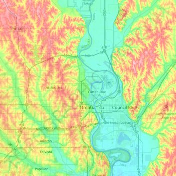
Nome: Mappa topografica Omaha, altitudine, rilievo.
Luogo: Omaha, Douglas County, Nebraska, United States (41.19059 -96.26820 41.39306 -95.87114)
Altitudine media: 338 m
Altitudine minima: 291 m
Altitudine massima: 413 m
Fai una donazione
Preparati per la tua prossima avventura:
In qualità di associato Amazon, questo sito riceve una commissione sugli acquisti idonei senza alcun costo aggiuntivo per te.
Altre mappe topografiche
Clicca su una mappa per visualizzarne la topografia, l'altitudine e il rilievo.