
Fai una donazione
Preparati per la tua prossima avventura:
In qualità di associato Amazon, questo sito riceve una commissione sugli acquisti idonei senza alcun costo aggiuntivo per te.
Mappa topografica Ipswich
Clicca sulla mappa per visualizzare l'altitudine.
Fai una donazione
Preparati per la tua prossima avventura:
In qualità di associato Amazon, questo sito riceve una commissione sugli acquisti idonei senza alcun costo aggiuntivo per te.
Ipswich
Ipswich experiences an oceanic climate, like the rest of the British Isles, with a narrow range of temperature and rainfall spread evenly throughout the year. One of the two nearest for which data is available is East Bergholt, about 7 miles (11 km) south west of the town centre and at a similar elevation, and similar river valley/estuary situation. The average July maximum of 23.2 °C (73.8 °F) is the third-highest for a major settlement in the country, behind London and Colchester, illustrating the relative warmth of the area during the summer part of the year. The record maximum is 35.2 °C (95.4 °F), set during August 2003. Typically, 24.9 days of the year will record a maximum temperature of 25.1 °C (77.2 °F) or above, and the warmest day of the year should reach 30.0 °C (86.0 °F), on average.
Fai una donazione
Preparati per la tua prossima avventura:
In qualità di associato Amazon, questo sito riceve una commissione sugli acquisti idonei senza alcun costo aggiuntivo per te.
A proposito di questa mappa
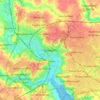
Nome: Mappa topografica Ipswich, altitudine, rilievo.
Luogo: Ipswich, Suffolk, England, IP1 1DD, United Kingdom (52.01793 1.11281 52.09793 1.19281)
Altitudine media: 30 m
Altitudine minima: -3 m
Altitudine massima: 56 m
Fai una donazione
Preparati per la tua prossima avventura:
In qualità di associato Amazon, questo sito riceve una commissione sugli acquisti idonei senza alcun costo aggiuntivo per te.