
Mappa topografica West Rutland
Mappa interattiva
Clicca sulla mappa per visualizzare l'altitudine.
A proposito di questa mappa
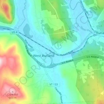
Nome: Mappa topografica West Rutland, altitudine, rilievo.
Luogo: West Rutland, Rutland County, Vermont, 05777, United States (43.57037 -73.06800 43.61950 -73.02223)
Altitudine media: 233 m
Altitudine minima: 141 m
Altitudine massima: 502 m
The town of Rutland was originally granted in 1761 as one of the New Hampshire Grants and named after Rutland, Massachusetts, the home of the first grantee, John Murrey. It was one of the most successful of those grants because of excellent farmland and gentle topography.