
Mappa topografica Zwingenberg
Clicca sulla mappa per visualizzare l'altitudine.
Zwingenberg
Zwingenberg lies on the western edge of the Odenwald at the foot of the Melibokus, at 517.4 m above sea level the Bergstraße's highest mountain. The municipal area's elevation varies between roughly 90 m above sea level in the outlying centre of Rodau and just under 300 m on the slope of the Melibokus. Zwingenberg's highest elevation is no one single mountain. Rather, it runs along the Melibokus's slope into the area of Auerbach, an outlying centre of Bensheim. The 100-metre marker at Zwingenberg railway station is taken to be the standard. In the west, Zwingenberg abuts the Hessisches Ried, and thereby the Rhine rift.
A proposito di questa mappa
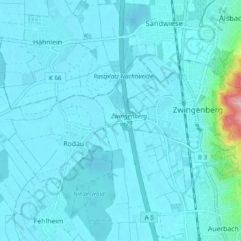
Nome: Mappa topografica Zwingenberg, altitudine, rilievo.
Luogo: Zwingenberg, Kreis Bergstraße, Hesse, 64673, Germany (49.71129 8.56049 49.73428 8.62693)
Altitudine media: 104 m
Altitudine minima: 89 m
Altitudine massima: 283 m
Altre mappe topografiche
Clicca su una mappa per visualizzarne la topografia, l'altitudine e il rilievo.
Wald-Michelbach
Germany > Hesse > Kreis Bergstraße > Wald-Michelbach > Wald-Michelbach
Altitudine media: 396 m