
Fai una donazione
Preparati per la tua prossima avventura:
In qualità di associato Amazon, questo sito riceve una commissione sugli acquisti idonei senza alcun costo aggiuntivo per te.
Mappa topografica Prunedale
Clicca sulla mappa per visualizzare l'altitudine.
Fai una donazione
Preparati per la tua prossima avventura:
In qualità di associato Amazon, questo sito riceve una commissione sugli acquisti idonei senza alcun costo aggiuntivo per te.
Prunedale
Prunedale is a census-designated place in Monterey County, California. Prunedale is located 8 miles (13 km) north of Salinas, at an elevation of 92 feet (28 m). The population was 17,560 residents at the time of the 2010 census, up from 16,432 at the 2000 census. Plum trees were grown in Prunedale in the early days of its founding but the trees died soon after due to poor irrigation and fertilizer.
Fai una donazione
Preparati per la tua prossima avventura:
In qualità di associato Amazon, questo sito riceve una commissione sugli acquisti idonei senza alcun costo aggiuntivo per te.
A proposito di questa mappa
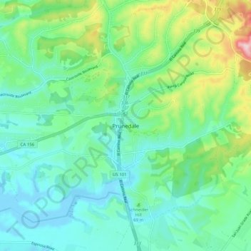
Nome: Mappa topografica Prunedale, altitudine, rilievo.
Altitudine media: 69 m
Altitudine minima: -8 m
Altitudine massima: 275 m
Fai una donazione
Preparati per la tua prossima avventura:
In qualità di associato Amazon, questo sito riceve una commissione sugli acquisti idonei senza alcun costo aggiuntivo per te.