
Mappa topografica Pattithanam
Clicca sulla mappa per visualizzare l'altitudine.
Pattithanam
Pattithanam is a village near Ettumanoor in the Kottayam District of Kerala, India. The name 'Pattithanam' is believed to be given by the Portuguese traders, who were looking for an ideal spot to build a church (St.Boniface Church). Pattithanam(Pattia Sthanam) means ideal place in Malayalam. Pattithanam village is the point of highest altitude on Main Central Road (MC Road). The early settlers in Pattithanam played a major role in establishing the educational and religious institutions in this area. During the early days, the nearest market was Athirampuzha and the agricultural produce was taken by bullock cart and head load from Pattithanm on market days. Pattithanam village is within Meenachil and Kottayam taluks of Kottayam District of Kerala.
A proposito di questa mappa
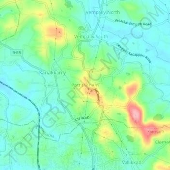
Nome: Mappa topografica Pattithanam, altitudine, rilievo.
Luogo: Pattithanam, Meenachil, Kottayam, Kerala, 686631, India (9.67936 76.53563 9.71936 76.57563)
Altitudine media: 38 m
Altitudine minima: 3 m
Altitudine massima: 123 m
Altre mappe topografiche
Clicca su una mappa per visualizzarne la topografia, l'altitudine e il rilievo.
Cherppungal Kulam Cheripurathu Padasekaram Karikombu
India > Kerala > Meenachil > Cherpunkal
Altitudine media: 29 m