
Fai una donazione
Preparati per la tua prossima avventura:
In qualità di associato Amazon, questo sito riceve una commissione sugli acquisti idonei senza alcun costo aggiuntivo per te.
Mappa topografica Ravensdale
Clicca sulla mappa per visualizzare l'altitudine.
Fai una donazione
Preparati per la tua prossima avventura:
In qualità di associato Amazon, questo sito riceve una commissione sugli acquisti idonei senza alcun costo aggiuntivo per te.
Ravensdale
Ravensdale is located in southern King County at 47°21′24″N 121°58′39″W / 47.35667°N 121.97750°W / 47.35667; -121.97750. It is bordered to the west by the city of Maple Valley. Ravensdale is 28 miles (45 km) southeast of downtown Seattle and the same distance northeast of Tacoma. It is situated at an elevation of 623 feet (190 m).
Fai una donazione
Preparati per la tua prossima avventura:
In qualità di associato Amazon, questo sito riceve una commissione sugli acquisti idonei senza alcun costo aggiuntivo per te.
A proposito di questa mappa
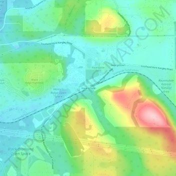
Nome: Mappa topografica Ravensdale, altitudine, rilievo.
Luogo: Ravensdale, King County, Washington, 98010, United States (47.33234 -122.00372 47.37234 -121.96372)
Altitudine media: 224 m
Altitudine minima: 166 m
Altitudine massima: 366 m
Fai una donazione
Preparati per la tua prossima avventura:
In qualità di associato Amazon, questo sito riceve una commissione sugli acquisti idonei senza alcun costo aggiuntivo per te.
Altre mappe topografiche
Clicca su una mappa per visualizzarne la topografia, l'altitudine e il rilievo.
Fai una donazione
Preparati per la tua prossima avventura:
In qualità di associato Amazon, questo sito riceve una commissione sugli acquisti idonei senza alcun costo aggiuntivo per te.
Lake Marcel
United States > Washington > King County
Lake Marcel is at an altitude of 295 feet (90 m) above sea level. The lake sits in a bowl at the top of Stillwater Hill on the east side of the Snoqualmie Valley, north of Carnation. It has two main areas of water connected by a channel, and several peninsular features make an extensive shoreline around the…
Altitudine media: 110 m
Fai una donazione
Preparati per la tua prossima avventura:
In qualità di associato Amazon, questo sito riceve una commissione sugli acquisti idonei senza alcun costo aggiuntivo per te.
Fai una donazione
Preparati per la tua prossima avventura:
In qualità di associato Amazon, questo sito riceve una commissione sugli acquisti idonei senza alcun costo aggiuntivo per te.
Snoqualmie River
United States > Washington > King County
The Middle Fork Valley is a popular recreational area since it is accessible during the winter due to its low altitude and close proximity to Seattle. For many years the Middle Fork Road extended 24 miles to Hardscrabble Creek, but was gated at Dingford Creek in June 2007, 18 miles in. The gate at Dingford…
Altitudine media: 212 m
Muckleshoot Tribe Reservation
United States > Washington > King County > Auburn
Altitudine media: 163 m
Clyde Hill
United States > Washington > King County
The top elevation is close to 375 feet. There are approximately 21 miles of public roadways in Clyde Hill.
Altitudine media: 48 m
Fai una donazione
Preparati per la tua prossima avventura:
In qualità di associato Amazon, questo sito riceve una commissione sugli acquisti idonei senza alcun costo aggiuntivo per te.
Fai una donazione
Preparati per la tua prossima avventura:
In qualità di associato Amazon, questo sito riceve una commissione sugli acquisti idonei senza alcun costo aggiuntivo per te.
Fai una donazione
Preparati per la tua prossima avventura:
In qualità di associato Amazon, questo sito riceve una commissione sugli acquisti idonei senza alcun costo aggiuntivo per te.
Mercer Island
United States > Washington > King County > Mercer Island
Mercer Island City Hall is located at 47°34′39″N 122°12′43.2″W / 47.57750°N 122.212000°W / 47.57750; -122.212000 (47.5775, -122.212). The peak elevation in the city is about 338 feet (103 m), near the center of the island.
Altitudine media: 39 m
Fai una donazione
Preparati per la tua prossima avventura:
In qualità di associato Amazon, questo sito riceve una commissione sugli acquisti idonei senza alcun costo aggiuntivo per te.
Donnie Chin International Children’s Park
United States > Washington > King County > Seattle
Altitudine media: 43 m
West Tiger Mountain Natural Resource Conservation Area
United States > Washington > King County > Issaquah
Altitudine media: 101 m
Fai una donazione
Preparati per la tua prossima avventura:
In qualità di associato Amazon, questo sito riceve una commissione sugli acquisti idonei senza alcun costo aggiuntivo per te.