
Fai una donazione
Preparati per la tua prossima avventura:
In qualità di associato Amazon, questo sito riceve una commissione sugli acquisti idonei senza alcun costo aggiuntivo per te.
Mappa topografica Cookson
Clicca sulla mappa per visualizzare l'altitudine.
Fai una donazione
Preparati per la tua prossima avventura:
In qualità di associato Amazon, questo sito riceve una commissione sugli acquisti idonei senza alcun costo aggiuntivo per te.
A proposito di questa mappa
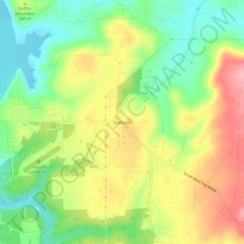
Nome: Mappa topografica Cookson, altitudine, rilievo.
Luogo: Cookson, Cherokee County, Oklahoma, 74427, United States (35.69093 -94.93995 35.73093 -94.89995)
Altitudine media: 253 m
Altitudine minima: 192 m
Altitudine massima: 328 m
Fai una donazione
Preparati per la tua prossima avventura:
In qualità di associato Amazon, questo sito riceve una commissione sugli acquisti idonei senza alcun costo aggiuntivo per te.
Altre mappe topografiche
Clicca su una mappa per visualizzarne la topografia, l'altitudine e il rilievo.
Tenkiller Ferry Lake
United States > Oklahoma > Cherokee County > Paradise Hill
The hydroelectric power station is remotely controlled from the control center at Fort Gibson Lake. Two generators, each rated for 17 megawatts, provide a total capacity of 34 megawatts (MWe). The facility can handle 40 MWe for a short period of time. However, the amount of power that can actually be generated…
Altitudine media: 258 m
Sparrowhawk
United States > Oklahoma > Cherokee County
Sparrowhawk is located in eastern Cherokee County along a large bend on the west side of the Illinois River. Much of the community is on top of Sparrow Hawk Mountain, a 1,080-foot-elevation (330 m) plateau that rises 360 feet (110 m) above the river. The CDP is bordered on the west by Oklahoma State Highway…
Altitudine media: 298 m
Fai una donazione
Preparati per la tua prossima avventura:
In qualità di associato Amazon, questo sito riceve una commissione sugli acquisti idonei senza alcun costo aggiuntivo per te.