
Fai una donazione
Preparati per la tua prossima avventura:
In qualità di associato Amazon, questo sito riceve una commissione sugli acquisti idonei senza alcun costo aggiuntivo per te.
Mappa topografica LaSalle
Clicca sulla mappa per visualizzare l'altitudine.
Fai una donazione
Preparati per la tua prossima avventura:
In qualità di associato Amazon, questo sito riceve una commissione sugli acquisti idonei senza alcun costo aggiuntivo per te.
A proposito di questa mappa
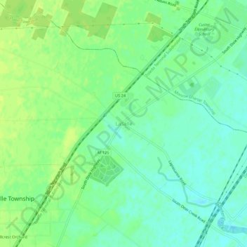
Nome: Mappa topografica LaSalle, altitudine, rilievo.
Luogo: LaSalle, Monroe County, Michigan, 48145, United States (41.84782 -83.47216 41.88782 -83.43216)
Altitudine media: 183 m
Altitudine minima: 175 m
Altitudine massima: 190 m
Fai una donazione
Preparati per la tua prossima avventura:
In qualità di associato Amazon, questo sito riceve una commissione sugli acquisti idonei senza alcun costo aggiuntivo per te.
Altre mappe topografiche
Clicca su una mappa per visualizzarne la topografia, l'altitudine e il rilievo.
Monroe
United States > Michigan > Monroe County
According to the United States Census Bureau, the city has a total area of 10.18 square miles (26.37 km2), of which 9.17 square miles (23.75 km2) is land and 1.01 square miles (2.62 km2) (9.92%) is water. Monroe sits at the lowest elevation in state of Michigan, which is the shores of Lake Erie at 571 feet…
Altitudine media: 182 m
Frenchtown Charter Township
United States > Michigan > Monroe County
The township is in eastern Monroe County and is bordered to the southeast by Lake Erie. Many of the township's communities are located near the lake. Sterling State Park is located along the southern edge of the township and is the only Michigan state park on Lake Erie. Small pieces of the township are…
Altitudine media: 181 m
Fai una donazione
Preparati per la tua prossima avventura:
In qualità di associato Amazon, questo sito riceve una commissione sugli acquisti idonei senza alcun costo aggiuntivo per te.
Fai una donazione
Preparati per la tua prossima avventura:
In qualità di associato Amazon, questo sito riceve una commissione sugli acquisti idonei senza alcun costo aggiuntivo per te.
Monroe
United States > Michigan > Monroe County
Monroe is in eastern Monroe County, with its city limits extending southeast3 miles (5 km) from the downtown to Lake Erie. The average elevation of the city is 594 feet (181 metres), decreasing to 571 feet (174 metres) at Lake Erie, which sits at the lowest elevation in Michigan. The Port of Monroe is the only…
Altitudine media: 182 m
River Raisin
United States > Michigan > Monroe County > Raisinville Township > Grape
Altitudine media: 192 m
Fai una donazione
Preparati per la tua prossima avventura:
In qualità di associato Amazon, questo sito riceve una commissione sugli acquisti idonei senza alcun costo aggiuntivo per te.
Frenchtown Charter Township
United States > Michigan > Monroe County
The township is in eastern Monroe County and is bordered to the southeast by Lake Erie. Many of the township's communities are located near the lake. Sterling State Park is located along the southern edge of the township and is the only Michigan state park on Lake Erie. Small pieces of the township are…
Altitudine media: 181 m
Fai una donazione
Preparati per la tua prossima avventura:
In qualità di associato Amazon, questo sito riceve una commissione sugli acquisti idonei senza alcun costo aggiuntivo per te.