
Fai una donazione
Preparati per la tua prossima avventura:
In qualità di associato Amazon, questo sito riceve una commissione sugli acquisti idonei senza alcun costo aggiuntivo per te.
Mappa topografica Montague
Clicca sulla mappa per visualizzare l'altitudine.
Fai una donazione
Preparati per la tua prossima avventura:
In qualità di associato Amazon, questo sito riceve una commissione sugli acquisti idonei senza alcun costo aggiuntivo per te.
A proposito di questa mappa
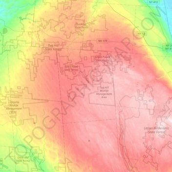
Nome: Mappa topografica Montague, altitudine, rilievo.
Luogo: Montague, Lewis County, New York, United States (43.55785 -75.86980 43.87785 -75.54980)
Altitudine media: 470 m
Altitudine minima: 218 m
Altitudine massima: 639 m
Fai una donazione
Preparati per la tua prossima avventura:
In qualità di associato Amazon, questo sito riceve una commissione sugli acquisti idonei senza alcun costo aggiuntivo per te.
Altre mappe topografiche
Clicca su una mappa per visualizzarne la topografia, l'altitudine e il rilievo.
Town of Lowville
United States > New York > Lewis County
Lowville /ˈlaʊvɪl/ is a town in Lewis County, New York, United States. The population was 4,888 at the 2020 census, down from 4,982 in 2010. The town is near the center of the county and is southeast of the city of Watertown. The town of Lowville contains a village also named Lowville, which is the county…
Altitudine media: 289 m
Fai una donazione
Preparati per la tua prossima avventura:
In qualità di associato Amazon, questo sito riceve una commissione sugli acquisti idonei senza alcun costo aggiuntivo per te.
Boonville Forest Preserve Detached Parcel
United States > New York > Lewis County
Altitudine media: 355 m
Village of Castorland
United States > New York > Lewis County > Town of Denmark
Altitudine media: 233 m
Fai una donazione
Preparati per la tua prossima avventura:
In qualità di associato Amazon, questo sito riceve una commissione sugli acquisti idonei senza alcun costo aggiuntivo per te.
Beaver River
United States > New York > Lewis County > Town of Croghan > Village of Croghan
Altitudine media: 256 m
Town of West Turin
United States > New York > Lewis County
West Turin has a warm-summer humid continental climate (Dfb). Winter is cold and very snowy, with most days not making it to freezing. Snow can fall anytime from October to May, and a consistent snowpack is expected from November to April. Due to its elevation, it is one of the coldest, snowiest, and wettest…
Altitudine media: 501 m
Fai una donazione
Preparati per la tua prossima avventura:
In qualità di associato Amazon, questo sito riceve una commissione sugli acquisti idonei senza alcun costo aggiuntivo per te.
Beartown State Forest
United States > New York > Lewis County > Town of Croghan
Altitudine media: 268 m